Showing posts with label Saskatchewan. Show all posts

Tuesday, August 31, 2010

Regina to Winnipeg

Day 26 – Tuesday August 31, 2010

Kilometres: 620.2

Time: 7 hours, 15 minutes (including gas stops and half an hour for lunch)

Weather:

Regina: Rain, 10 C at 10 AM

Brandon: Cloudy, 16 C at 2:30

Winnipeg: Cloudy, 18 C at 6 PM

The weather is really getting to me. I haven’t been warm since I was in the hotel in Edmonton. None of the other hotels have the heat on, and it is getting pretty darn cold at night. It rained all night and it was also cold. In the hotel room it was 13 C. I slept in my street clothes because they are the warmest clothes I have. The hotel provided an extra blanket.

I delayed leaving in the morning in hopes that it would warm up and perhaps clear up a bit. It had almost stopped raining when I left, but the temperature had not improved.

It was yet another day of being lucky with the rain. I could see the storms, which were only regular grey clouds of rain, and, thankfully, not thunderstorms. I was fortunate to miss the worst of it. A few times I could see the raining coming down and heading southeast towards the highway … and my future path. I just pulled on the throttle harder and tried to beat the storm.

By the time I arrived in Brandon (the wheat capital of Canada) the worst of the storms were over and the sun was trying to poke through the clouds. It also warmed up noticeably. I’ve discovered that I cannot ride when it is 8 C or colder. Or at least I can’t ride in the gear that I have with me on this trip. At 10 C, I am miserable, but still able to ride. At 12 C, it is tolerable and I can almost enjoy myself. At 14 C I am a happy rider, even though I’m wearing two pairs of gloves, five layers on my top half and four on my lower half.

The wind was a bit gusty at times, especially when I went over bridges, which, thankfully, are few and far between out here.

Just east of Portage la Prairie the landscape noticeably changed. There were many more trees and at one point I rode through a spruce forest.

Just as I reached Winnipeg it began to cloud over, but it didn’t rain. I’m staying in the east end of the city and could have taken the ring road, but instead I went right through the city and found the hotel without any trouble. I think I understand the basic layout of the city and if I were here for a week I would be hard pressed to get lost in Winnipeg.

My one regret about arriving late in Winnipeg is that I won't have time to visit the Forthwyte Alive, which has bison (I have been corrected a number of time that they are NOT buffalo) gated in a natural prairie setting. I've only seen bison hides and would really love to seen one of these huge, wonderful beasts alive and in person.

I’m staying in the same hotel, and even have the same room that I had on my trip west. As soon as I arrived, I ate dinner, drank a beer, then changed into my swimsuit and jumped in the pool. As I have a short ride day tomorrow, I may have one final swim first thing in the morning. Next stop: Ontario.


Saskatoon to Regina

Day 25 – Monday August 30, 2010

Kilometres: 456.9

Time: Five hours, 45 minutes(riding time)

Weather:

Saskatoon: Overcast, 12C at 10:30 AM

Batoche: Partly cloudy, 18 C at 2 PM

Regina: Rain, 12 C at 7 PM

I really should read my itinerary the night before I ride. I thought I skipped over visiting Batoche yesterday because of weather. It was actually planned for today. This morning I weighed my options: Go to Regina early and see the RCMP Museum, or go to Batoche. After a quick breakfast I packed up and headed north to the site of the last Metis battle. I reasoned that there is a good chance of me going through Regina again, but only a small chance of me ever being close to Batoche again.
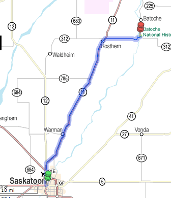


You don’t just stumble across Batoche. It is so out of the way that you have to know it’s there. I got off of Highway 11 and headed east on 312 for a while before going north on 225. Both 312 and 225 are not well travelled. I passed seven cars going in the opposite direction on both 312 and 225. If I were to breakdown my only witnesses would be the ducks on the ponds. The grain fields go on forever, but I still deny that Saskatchewan in flat. Both the North and South Saskatchewan rivers have created deep, wide valleys, similar to what I’d seen in Qu’Appelle Valley. Stands of trees break up the farmland, and I’ve often wondered if the Prairies without all the farm fields would look similar to Southern Ontario.

Speaking of similarities, highways 312 and 225 reminded me of the concessions and regional roads of Southern Ontario: farmers fields on both sides, a small road ditch, hardly a road shoulder, and quilt work patches of pavement.

I arrived at Batoche a bit before noon. I turned off onto a paved road, which quickly turned to hardpack and then gravel. Don’t these people think of motorcycles? The parking area is on grass, so I guess they don’t think of motorcycles at all. There were only six cars in the lot, so I had high hopes that I wasn’t going to be surrounded by screaming kids.

The national park is undergoing revitalizing construction, so the reception area is in a construction trailer. I paid my $7.80 and was lead to another trailer to watch a short film about the battle. I really think that third semester broadcasting students could have done better. All the key characters were represented by what looked like hand-formed plastic figures. They probably did it this way so the narrative could be overdubbed in French and English, but it looked cheaply done. The six other people in the room were shuffling our feet and staring around presumably from inattention to a rather boring film. I later learned that we were some of the last people to see the film as it is being re-shot for next year.

After the film we were allowed to walk around the site and interact with the few period costumed interpreters. The first building I went into was the original church. Many of the statues, and other religious artefacts are original to Batoche. Beside the church is the rectory. There I met one of the interpreters who walked me around the three rooms on the ground floor. All the items in the rectory are from that time period, but not necessary from the original Batoche rectory. In many ways it reminded me of the recreated rooms I walked through in the big house at Lower Fort Garry.

On the second floor the priest kept the post office, a prayer room, a room for visiting priests and another bedroom (his bedroom was on the first floor, so I don’t know who slept in the upstairs room.

In the corner I saw a piece of furniture that look similar to the oak piece I’d given to Margo a few years ago. The two upper drawers were slightly different and this piece was maybe 15 cm taller. I asked the Parks Canada person if she could open it for me as I was interested in seeing how the handle and catch worked. Also, the colour of the Batoche pieces is white. I had stripped off five layers of paint on the oak cabinet, and I think the last one was white. Hey, Margo, it looks like I gave you something from the 1880s or 1890s. You may want to paint it white.

With my interested in the piece, the Parks Canada guide directed me back downstairs to look at another piece that was painted red. She said it was painted using milk paint, which is no longer made. I corrected her on that, and after looking at the piece I suggested that they looked in the Lee Valley catalogue, specifically for ochre milk paint. It is very close in shade, but the Batoche piece maybe slightly lighter in colour.
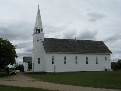
Here's a picture of the church with the rectory behind it. Both took shots from the RCMP's Gatling gun during the battle.

I had spent too much time talking, and had to hurry the remainder of my visit. I went to the ridge where the battle took place. It was a lovely view of the South Saskatchewan River. I turned around to look back at the church and saw this:


From there I started to walk towards the Metis gun pits, but they were half a kilometre away. Was it worth walking a kilometre to see holes in the ground with my time at Batoche running short? Instead I turned around and walked to the Batoche cemetery.

The guides told me to follow the paths to the different areas. They aren’t really paths, as the area is mostly grass. All they have done is taken a tractor and mowed down three metres of the grass. If you go off the mowed area, you will be standing in grass up to your waist. The path continued around the side of cemetery, but I always like taking the front door when I can find it.

The gates of the cemetery, which is still used by the parish, were locked shut, but the black gate had a simple catch on it. I pulled in the catch and pushed open the gate. Everyone from Batoche to Saskatoon must have heard me open the heavy metal gate. It has never seen a drop of oil in its life. Wow, was that ever loud … and I had only opened it a few inches. I paused for a second. Was I supposed to use the gate? Oh, well, I’d already started making a noise, so I may as well finish. An yes, I remembered to close the gate behind, just in case they didn’t hear me open it.

I was looking for the grave of Gabriel Dumont, Louis Riel’s military leader. I found several members of his family, including his brother and sister, but I didn’t see his grave, even though I was told he was in the cemetery. There was a plaque on a rock commemorating what he’d done, but I couldn’t find the grave marker.

I found the grave of one of the RCMP (or were they the North West Mounted Police by that time?) soldiers killed in the battle. All the other bodies of soldiers killed in the battle were returned to their families in Ontario.
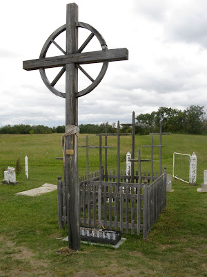

There is also a wooden fence around the graves of the Native fighters who lost their lives at the battle. What I found interesting about the cemetery is the mix of English and French people buried there. Many of the French graves had the inscription, “Ici repose le corpes de …. And then ended in RIP. Generations of the same families are buried here, but interestingly, the cemetery is not divided up by family. This didn’t help me at all with finding Gabriel Dumont’s final resting place. Also, the graves are not arranged in rows. It’s a bit of a jumble.

In the end I gave up looking. The wind had dropped and the flies, especially the mosquitoes were coming out by the millions.

I didn’t see the remainder of the Batoche site, and I know I missed quite a bit, but I couldn’t stay any longer as it was getting close to 2 PM. I had at least a three and a half hour ride ahead of me.

As I stood beside my bike and started to get ready to head out, three tourists from Saskatchewan struck up a conversation with me. They had also travelled extensively throughout Canada. They said that they spent 11 days in Newfoundland and still didn’t have a chance to see everything they wanted to. It sounds like that will be a two-week trip for me and not the one-week I had originally planned. We also started talking about the geography of Saskatchewan. Apparently there are three distinct parts to the province. Batoche is on the edge of the valley. North of here it’s all lakes, trees, and wilderness. The southern part of the province is more hilly, especially the Cypress Hills, which I’d missed seeing because of poor weather a few weeks ago.

As I got on the bike, I noticed that it was 18 C, the warmest weather I’d had since leaving Vernon nearly a week ago. The sun was attempting to poke out from behind the clouds, and for a while it was winning. But as I rode south, the clouds again increased.

I stopped for gas in Saskatoon and kept going south. I knew I had to stop for gas one more time before reaching Regina, and I wanted to prolong that stop for as long as possible. If I timed everything right, I could get gas and quick bite to eat and not have to worry about food once I arrived in Regina.

I stopped at 5 PM at the small town of Davidson. My fingers were numb and so were my toes. The temperature had dropped to 14 C. I needed to warm up. I fuelled up both the bike and myself and then stretched my legs for a bit. My half an hour break would cost me, though, because about 10 minutes after I left Davidson, the temperature dropped even further.

For the next hour and 15 minutes I rode in the rain, which I don’t mind, but I also rode like a frozen Popsicle. Thank god I bought that $10 piece of plastic called a cruise assist. It slips over the throttle and I just lean on it and the throttle opens. It means that I don’t have to grip the throttle all the time. My hands were so cold that I couldn’t grip the throttle even if I wanted to. They simply rest on the grips and turn the bars when I come to a curve in the road. Once again I’m thankful I’m not riding the twisty roads in BC.

I arrived at the hotel craving a hot coffee, but this one doesn’t have an in-room machine, so I had to go across the street and buy one from Tim Hortons, which means I was desperate.

Tomorrow I’m heading to Winnipeg and then I’ll retrace my steps home.


Monday, August 30, 2010

Edmonton to Saskatoon

Day 24 – Sunday August 29, 2010

Kilometres: 578.0

Time: Eight hours (including stops)

Weather:

Edmonton: Overcast, 8 C at 9:45 AM

Saskatoon: Overcast, 10 C at 5:45 PM

This was an absolutely unremarkable day. It was cold, with periods of rain throughout the day. My only stops were for gas and food, which where at the same places. The only variance was a short diversion into Battleford.

Battleford was totally dead. I only saw two kids playing on the street and one person mowing the front lawn. All the stores were closed and almost every house had a car in the driveway. It seems that no one goes out on a Sunday. The town hall was erected in 1912 and it looks like the post office building was also built around the same time. I went up and down a couple of streets and was quiet surprised to find that about 75 per cent of the homes are mobile homes that have become permanent.

There were only two places open in Battleford: one was a Petro Canada station and the other one was a Shell station. Both were on the highway. I stopped at the Petro-Can for gas. It also seems like this is the only available washroom in town. There was a lineup.

Next I drove through North Battlefords (collectively they are called “The Battlefords”), which had people on the sidewalks, cars on the streets, and open businesses.

Originally, I had planned to detour just prior to The Battlefords and visit Cut Knife, tour Fort Battleford, and then ride northeast to Batoche. Again, the weather convinced me otherwise. I really, really, REALLY hate being cold. By the time I’d reached The Battlefords, I’d lost the feeling in the tips of all my fingers. All my planned activities were outdoors, which meant I was cancelling them.

During the hour and a half ride from The Battlefords to Saskatoon, I spend most of the time hunched down over my tank trying to get a bit of protection from my windshield. As I type this out, I have very stiff shoulders and am looking forward to a visit tot he chiropractor next Tuesday.


Saturday, August 14, 2010

Swift Current to Fort MacLeod


Day 8 – Friday August 13, 2010

Time: 7 hours, 45 minutes (including numerous stops)

Kilometres: 459.9

Weather:

Swift Current: Overcast and foggy, 12 C at 10 AM

Fort MacLeod: Overcast, periods of rain, 11 C at 5:30 PM

Last night was a Hotel California night. You know, “You can check out any time but you can never leave.” It was a bit creepy. I check in just after 5 PM and I was the only guest. The pool was closed, the restaurant was closed and the place looked like it was ready for a wrecking ball. Someone should put this Howard Johnsons hotel out of its misery. It was the second worst hotel I’ve ever stayed in. The only reason I didn’t get on my bike and go to anther hotel is because I was too tired, too wet, and too fed up with being on the bike. Enough was enough and I needed to relax.

The place wound up having about a dozen guests … many of them watching the Saskatchewan Roughrider take on some other team. These people are really into their football. They are probably as fanatic as Canadiens fans.

Anyway, I got up the morning and just wanted to hit the road and get the hell out of Dodge. I packed everything up and was ready to throw my bags on the bike. But then I looked outside and knew that today’s weather was going to scrap more of my tourist plans. It was rainy and foggy and I couldn’t see more than 5 kilometres in front of me.

At my first gas stop, I met the German guy from yesterday’s storm. He’d also stopped in Swift Current. He gave me his pen (most people have business cards) and invited me for a coffee when I go through Lilloot. He says he has the only radiator repair shop in town.

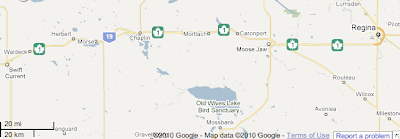
The fog didn’t lift. In fact, it sunk even closer to the ground as I rode westward. The plan was to loop south and ride through the Cypress Hills and then meet up with T’Can near the Alberta border. When I got to the turn off, visibility was only about 3 kilometres. There wasn’t any point in going south if I couldn’t see anything, so I continued westward. (On the following map, my route would have been to head south on hwy 37 then west on 13 (not on the map) and then north on hwy 21.)

By the time I hit the Alberta border the fog was lifting, but it was raining and the wind was picking up. I didn’t even stop at the “Welcome to Alberta” sign because I was in no mood to prolong the ride.

The further west I went, the worse the weather. Just before Medicine Hat, the sky opened up with a good soaking. I kept riding as I could see the road. It was a heavy concentration day, but even so, my mind wandered. I just haven’t been eating properly since I started the trip. It seems that everywhere I go the most convenient places to eat are Subway and Tim Hortons. I began to crave real food. Fruit, vegetables, good protein that isn’t stuffed between two pieces of bread. My list grew to salmon on a plank with a salad, cheese quiche with broccoli and corn on the side. I hadn’t had a banana or grapes in over a week. I pulled into Medicine Hat for lunch, found a Kelsey’s and they coincidentally have salmon served with a salad for lunch.

Some of the smaller storms, I contended with, but when I saw a big one, I knew to pull on the throttle and get into the next town. The next pull over was in Tabar. I pulled into a Tim Hortons, ordered a coffee and a muffin and watched while two storms flew over me.I quickly got back on the road, but as my hands were cold, I wore both my insulated waterproof gloves and the rain-off gloves. That helped a bit. I didn’t get very far before the skies started to look menacing again. At least it didn’t look as bad as what I’d gone through yesterday, but the wind was wicked. I was fighting with the bike all the time. At one point I thought I should pull over, but the next town was only a kilometre away and I could still see.

I pulled into Bow Spring, got gas and waited for another storm to pass. They were sweeping down from the north. I could see them coming and it was a bit of a game to judge whether I could make it to the next town before the next storm hit.

While in Taber, I saw what I fist thought was a family of Mennonites, simply because the way they were dressed. They were clearly farmers, but I didn’t think Mennonites were in Alberta and I know they don’t frequent Tim Hortons. When the family talk amongst themselves, I didn’t recognize the language. Perhaps they are Dukeabours (sp?)

The ride from Taber to Lethbridge wa pretty much the same: strong wind and quick, messy storms rolling through. I kept my eye open for downbursts, but thankfully, didn’t see any.

To give you an idea of how strong the wind was, I had to constantly lean the bike to the right to keep it upright. When I passed a stand of trees (not that often) or a train on the tracks that run parallel to the highway (more often than trees) or grain elevator ( every few kilometres) the wind would cease for a second, and then whip around and blow from my left., or sometimes, I’d just be sheltered and it was like normal riding. It was one of the best upper body workouts I’ve had in a long time.

Just outside of Lethbridge, I rode over a butte and saw the foothills of the Rockies. At first I wasn’t sure if I was looking at the foothills or storm clouds, but the closer I got, the clearer the outline became. I was almost at the end of my prairie journey.

I pulled into Fort MacLeod, check into the motel, unpacked my bags and had a quick shower. I needed to warm up (what else is new?) and feel clean after such a rotten day on the road.

The weather started to clear up a bit. It was still cold and windy, but at least it wasn’t raining. I walked down main street and found that one the street behind me is the actual fort. I hope to have time in the morning to quickly visit it.

I am so looking forward to tomorrow’s planned activities. The four things I’ve planned have been on my “to do” list for several years. See the Hillcrest mine site, go down the Bellevue coal mine, see the town (or what’s left of the town) of Frank, and then ride through the Crow's Nest Pass.

Thursday, August 12, 2010

Yorkton to Swift Current

Day 7

Time: 8 hours, 45 minutes

Kilometres: 447.5

Weather:
Yorkton: Mostly cloudy, 22 C at 9:15 AM
Swift Current: Raining, 12 C at 5 PM

Last night I prepped my self and the bike for rain. I had all my rain gear in the hotel room and my riding clothes. Everything was packed on the bike overnight except my toothbrush and computer. I did all this because I know that when there is a chance of sever thunderstorms (as they were calling for) the storms usually go off with a bang in the heat of the afternoon.

I had the best night's sleep of the trip. I now know the difference between staying at a $70 a night hotel and a $100 a night hotel. They had a strict no noise policy in effect from 11 PM to 9 AM. Three or four 20-something boys were very loud in the area after 10 PM and they were told to leave (thankfully). As the night was off to a promising start, I didn't even put my earplugs in - and I didn't need them.

I had a quick breakfast in my room and pulled out of Yorkton at 9:15. the sky was overcast, but at least it wasn't raining. I put on all my rain gear except for my rain-0ff gloves, which I prefer not to ride in unless necessary. I rode through Yorkton and then headed south on Highway 10 towards Regina. In front of me was blue sky, but to my right, well off in the distance, were black clouds. I could see rain falling from the clouds and I planned to out race the storm to Regina.

In about half an hour I was riding under blue skies, but I could still the rain off to the north. Fortunately, the storm stayed away from me as I rode southwest.

I've always remembered the big, huge skies of Saskatchewan from when I drove through it 18 years ago. It was just as I recalled. You can see for ever. I still disagree when people say the Prairies are flat. They are rolling hills, much like Southern Ontario farmland. In Southern Ontario, we have the Niagara Escarpment as the main feature, while is Saskatchewan, they have rolling hills and beautiful valleys. Fort Qu'appelle and the Qu'Appelle Valley were breathtaking.

Bridge construction slowed traffic to a crawl as I descended into the valley. The Qu'Appelle river was very wide and the area was alive with water birds, including a group of four white pelicans which flew almost right over me. The ribs of the valley is what made the the area even more beautiful. Unfortunately, I couldn't get a good photo, so I've stolen this one from the Internet:

There was hardly a cloud in the sky, but the the day was heating up quickly. It was only 10:45 and the temperature was at 30C. I stopped in a Dairy Queen (my first of the trip) and then continued towards Regina.

Not long after leaving Fort Qu'Appelle, the sky in the west started to get cloudy. By the time I'd reached the junction of highways 10 and 1, I knew it would be foolish of me to stop in Regina. I wanted to see the RCMP museum and the changing of the guard at 12:30. I knew if I stopped that I would get stuck in some unpleasant weather. Perhaps I'll be able to see some of Regina on my return trip.

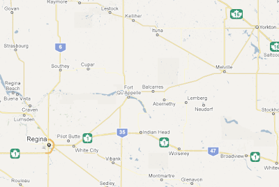
Here's a map of where I went during the first part of the day:

On the Saskatchewan licence plate is the catch-phase "Land of Living Sky." Watching the sky move is mesmerizing. I could see a solid storm front. The line in the sky is perfect. On the far side of the line was a small line of cumulus clouds.
Behind them were towering cumulus monsters. I watch the thermals push
the clouds higher, while the underside of the clouds grew darker. It was a fantastic sight to see.

I was keeping an eye on the storm but also keeping an eye open for towns. I didn't want to get stuck on the highway (the speed limit is 110, and I get nearly run over when I do 120 - I'm slow compared to others) in a downpour. My timing was perfect. As I pulled into the "Pilgrim Centre" in Caronport (just west of Moose Jaw). I'd been heading towards the storm for just over an hour. So I guess that means I saw it about 110 to 125 kilometres in the distance.

I hung out at the Centre for about an hour (it had a Husky gas station, Subway restaurant, and a convenience store). It was hardly raining when I left, but I decided to put on my rain-off gloves just incase ... and I was about to need them.

The sky cleared up quickly, but again, in the distance I could see storms. Just after Moose Jaw the landscape changed from gently rolling hills full of crops to ranch-type land. It was much more hilly, with lots of marshes. I saw a red-winged blackbird for the first time since leaving Ontario.

I was keeping my eyes on two storms: one to the left and the other to the right. I couldn't really see the one of the right, but I knew it was there. Over the tops of the large hills, I could see the mushrooms of distant cumulus clouds. These suckers were big!

The storm to my left was going to break first, but I was fortunate and it missed me by some distance (I really can't judge distance on the Prairies, but I would guess it missed me by about 5 kilometers). The storm to my right was really getting interesting and the more I was thinking "Oh, wow, this looks so cool!" I also knew "Oh, wow, this is really not good."

Since my stop at Caronport, another rider and myself passed each other a few times. He is a faster rider than me, but he also stops more often, so I would pass him while he stopped.

I knew that this storm was going to be a whopper when I was that the second line of thermals were dark blue. I love watching weather, so I knew I was in big trouble and needed to find shelter as soon as possible. In my rearview mirror I saw the other rider had caught up with me. In front, the storm was now sending down forks of lightning. The next town was only a couple of kilometres away. I pulled on the throttle.

Huge gusts of winds hit me from the side ... one even pushed me slightly into the passing lane. Within 10 seconds the wind picked up and down came huge globs of pelting rain. I didn't last long - maybe 30 seconds. There was a white camper van in front of me. If it wasn't for the camper, I wouldn't know which way to steer. I couldn't see a thing. It was time to pull over even though there was no shelter in sight.

I pulled off as far as I could onto the hard shoulder. Behind me, the other rider had also pulled over as well. I planned to leave everything on the bike and head down into the ditch at the side of the road. But when I looked back, I saw that the motorcycle behind me had gone over. I ran over to the rider, who was picking himself up from the shoulder. Together we picked up up his monster bike (it is the Yamaha version of a Honda Gold Wing - I would guess around 900 pounds without luggage). He pulled out a tarp from under his passenger seat and we hunkered down under it in the grass to wait out the storm.

We were there for about 30 seconds when a woman lifted up one end of the tarp. She was in a car and pulled over behind the other bike. She invited us into her car to ride out the storm. I wasn't about to wait for another invitation, and quickly jumped in the back seat of her car. We sat there, making small talk for about 15 minutes while the wind outside rocked the car back and forth.

She was from Regina and on her way to Lethbridge. The other rider, who I couldn't understand very well because of his thick German accent, was returning home to Lillooet, BC from a ride through Ontario.

It was really nice of woman to pull over and give us shelter. I know in the big city that sort of thing just doesn't happen. It's every person for themselves. What a shame we've lost that trust in others and the willingness to help others.

When the rain lightened up, I was the first one out of the car. I didn't want to overstay my welcome. I don't mind riding in normal rain, and that is what the storm had turned into. I asked the other rider if he needed an hand with anything (there was a broken off piece of something-or-other from his bike on the ground, and he still had to fold up the tarp). He said he was fine. I was quickly back on the road and searching for Swift Current.

I hadn't gone more than a kilometre when I saw the turn off to Waldeck. I'm glad that I didn't know how close I was to a turn off or I may have tried to push for it. So, my riding lesson for today is: Turn off to the shoulder when it gets too bad. I don't need a town to be safe.

About 10 minutes later I pulled off the highway and into Swift Current. It was still raining as I unpacked the bike. At least all the bugs from the Prairies have been blasted off the bike in nature's car wash. I didn't bother putting the cover on the bike as I'm hoping it was stop raining tonight and give my bike a chance to dry out. I don't want to trap all that moisture under a cover. Meanwhile, my hotel room is littered with drying clothes. It's supposed to rain again tomorrow afternoon, but hopefully not in such a dramatic fashion.

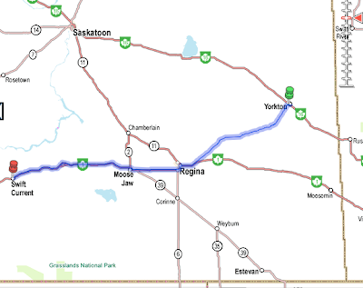
Sorry there aren't any pictures, but I was a bit too busy to take the rain cover off of my tank bag to get the camera. By the way, the rain cover doesn't work. The contents of that are hung out to dry. Here's a full map of the days ride:

Pictures from the Prairies

Here are the pictures I was going to post from yesterday's ride, but was too tired to last night.

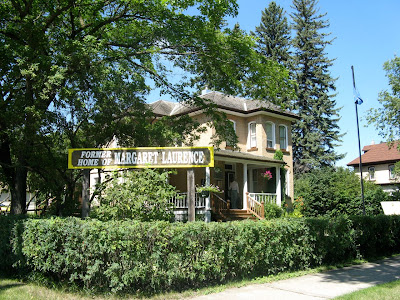
First up, I stopped in Neepawa, Manitoba for gas and saw the sign indicating that house where author Margaret Laurence grew up was just around the corner. I couldn't pass up the opportunity to at least drive by it. And I was afraid of riding by it if it wasn't well signed.

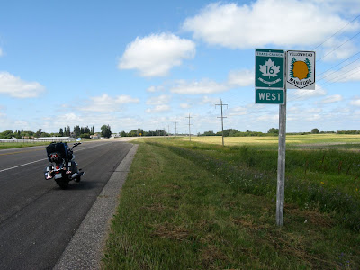
I also FINALLY found a relatively safe place to pull over where there is a hard shoulder. Yup, I'm on the Yellowhead Highway heading west towards Yorkton. I didn't realize that there are two Trans Canada Highways out in the west. The first is the southern route and the northern route. The Yellowhead is the northern route and goes from Portage la Prairie up through Jasper. The southern route goes through Banff.

I crossed over into Saskatchewan but didn't realize until this morning that I'd crossed into Mountain Time. It would be nice if they put up a sign to let us tired travelers know these thing. Of course Saskatchewan is the only province that doesn't participate in daylight savings, so it is difficult to know whether or not to move the clock or not.

Wednesday, August 11, 2010

Winnipeg to Yorkton

Time: 7 hours, 10 minutes

Kilometres: 465.7

Weather:

Winnipeg: Sunny, 24 C at 10 AM

Yorkton, Sask: Partly cloudy, 28 C at 5 PM

I really don't understand why it took me so long to ride so few kilometres. I think I hit every red light on the way out of Winnipeg, but other than that, it was pretty smooth riding all the way through.

From Portage La Prairie up to Gladstone (small town about an hour or so north of PLP) there were thousands of those little white butterflies. You know the ones. They fly like they are drunk 'cause they just can't fly in a straight line. Anyway, what ever was growing at the side of the road was their favourite plants. Unfortunately, they all too often flew in front of me. At times it was almost like, but not quite as intense as light snow flurries.

I also discovered that dragonflies eat these butterflies. I think it is also mating season for dragonflies and there were a few flocks? schools? squadrons? ... I don't know the right term. But I could see them flying on the road ahead of me and there was nothing I could do to avoid them. Between the butterflies, dragonflies and the odd bee, there was barely a spot on my windshield free of bug splatter. I was also covered. Boots, helmet, arms and legs.

I pulled over for gas in Neepawa, Manitoba (is it pronounced Nee-pa-wa or Neep-awa?) and stumbled upon the childhood home of author Margaret Laurence. I didn't go inside as I was already running behind schedule, but I took a couple of photos.

A quick note about today's pics: It's just passed 11 PM and I haven't even looked at the pics I took today. I'm just too tired to do that now and will post those pics tomorrow night.

After Neepawa, the bug problem diminished quickly. I stopped in Russel, which is just east of the Sask border. Originally, I had planned to head north to visit the grain elevator museum, but as it was already close to 4 PM, I stopped for lunch at Subway and then headed west. I will have to ride another trip out this way in the future as I have so far missed three things on my "to see" list."

I rolled into Yorkton shortly after 5 PM. I soon found out about the weather warnings popping up all over the province. After a quick swim in the pool, I began repacking my gear and getting my Gore-Tex ready. Currently, the bike is packed except for a few items and will be ready to roll in about five minutes. The forecast is calling for rain starting tonight and going all the way through tomorrow. There is a good chance of thunderstorms. From weather watching, I know that sever thunderstorms usually pop up in the afternoon. I plan on starting early in the morning and will hopefully miss the worst of the weather. I will most likely miss another tourist destination in Regina and just keep heading west towards my hotel.