Showing posts with label Alberta. Show all posts

Monday, August 30, 2010

Edmonton to Saskatoon

Day 24 – Sunday August 29, 2010

Kilometres: 578.0

Time: Eight hours (including stops)

Weather:

Edmonton: Overcast, 8 C at 9:45 AM

Saskatoon: Overcast, 10 C at 5:45 PM

This was an absolutely unremarkable day. It was cold, with periods of rain throughout the day. My only stops were for gas and food, which where at the same places. The only variance was a short diversion into Battleford.

Battleford was totally dead. I only saw two kids playing on the street and one person mowing the front lawn. All the stores were closed and almost every house had a car in the driveway. It seems that no one goes out on a Sunday. The town hall was erected in 1912 and it looks like the post office building was also built around the same time. I went up and down a couple of streets and was quiet surprised to find that about 75 per cent of the homes are mobile homes that have become permanent.

There were only two places open in Battleford: one was a Petro Canada station and the other one was a Shell station. Both were on the highway. I stopped at the Petro-Can for gas. It also seems like this is the only available washroom in town. There was a lineup.

Next I drove through North Battlefords (collectively they are called “The Battlefords”), which had people on the sidewalks, cars on the streets, and open businesses.

Originally, I had planned to detour just prior to The Battlefords and visit Cut Knife, tour Fort Battleford, and then ride northeast to Batoche. Again, the weather convinced me otherwise. I really, really, REALLY hate being cold. By the time I’d reached The Battlefords, I’d lost the feeling in the tips of all my fingers. All my planned activities were outdoors, which meant I was cancelling them.

During the hour and a half ride from The Battlefords to Saskatoon, I spend most of the time hunched down over my tank trying to get a bit of protection from my windshield. As I type this out, I have very stiff shoulders and am looking forward to a visit tot he chiropractor next Tuesday.


Edmonton

Day 23 – Saturday August 28, 2010

Kilometres: 38.6

Time: Not much

Weather:

Edmonton: Overcast, windy, 8 C at 9:30 AM

The weather had not improved overnight, and after looking at the forecast, I knew I’d have a few cold and rainy days ahead of me. My first job today was to get an oil change. I’d looked on the Yamaha website prior to leaving Toronto, so I knew where all the rapid service centres were located. The closest one was 15 km away, which. After riding all this way, seemed to be pretty close.

I was in and out in about 45 minutes. I’ve learnt something very important from visiting a number of dealerships on this trip: most of them sell all the same stuff and most of it is crap. The only place that sold a good variety was Blackfoot in Calgary. If someone were really smart, and had the money, they would open up a store that stocked quality motorcycle accessories with a large variety. Yes, the items would cost more, but I really believe that people will pay for quality goods, with a solid warranty, and backed up with exceptional service.

After the oil change, the service manager paid me a very nice compliment. He called me a real rider because I’d put black electrical tape all over the fake chrome parts on the front of my bike. He said that that was an old trick that riders in the Prairies had been doing for a long time. He said that I had caught on quickly and was using my head. I didn’t tell him that I’d taped up some of it while riding in Toronto, and then the remainder of it at the Central Time Zone change turnout, also in Ontario. It was waaaay before I’d arrived in Prairies.

After the oil change I rode over to West Edmonton Mall. I arrived around 11 AM and had to park nearly in the furthest parking spot. Fortunately, I’d removed most of items from my saddlebags so I rolled up all my rain gear and tucked them away. I had the cloth bag for my helmet, so I put the helmet in the bag and slung that over my shoulder. At least I wouldn’t boil while walking through the mall and I knew my helmet was safe.

I really don’t know how to describe WEMl. I guess the closest I could come is to take Yorkdale, Scarborough Town Centre and Sherway Gardens and combine them. Then add in a giant wave pool, a hockey rink, mini putt, and sea lion show. I know that I’m missing a few things, but I’m sure you get the general idea.

When I say take the three malls and combine them, I’m also including the stores. For instance, I saw two Payless shoe stores, three La Senza stores, and three Lids stores (I thought of you Anthony). There are also the departments stores, such as HBC, Zellars, and Sears. But I didn’t go to WEM to go shopping; I wanted to see the different “streets” or areas. For instance, did Bourbon Street make me feel as if I were in New Orleans? Umm, no, not at all. I was greeted by a Boston Pizza, a Tony Rona (ribs) and Moxies (restaurant chain). This is not my idea of New Orleans. The lights were dim to give it ambiance, and the store facades were attempting to look like New Orleans. It may have worked, except for the stores themselves. They are merely dressed up versions of what I could find in most malls. It was nothing special.

Next, I visited “Chinatown.” It had the exact same problem that Bourbon Street had. All the store signs were in English and Chinese, but I really can’t buy into being in Asia when I have a Roger’s store facing me. At the end of the “street” was a Chine-inspired food market. I didn’t bother going on, but I did overhear some one say that the inside looked just like Asia only cleaner.

I stopped by to look at the wave pool. I can see why this would be such an attraction, especially during the Edmonton winters. I walked back through the mall and came across only one store that I was interested in. It is called Millennium and it sells goth clothes. Unfortunately, it sells the cheap stuff (see my mini-rant on quality motorcycle accessories), which I’d first seen in Vaudeville and Trash in New York City. This stuff will fade and fall apart in no time. I really have to take extra care with my lower end goth clothes, such as the Tripp brand, because the material is too thin and the stitching isn’t of good quality. Hence my improved hand sewing over the last couple of years. I’ll stick to Living Dead Souls, but it’s so unfortunate that it’s not available in North America.

I was back on my bike by 12:30 and cars were circling me for my parking spot. I had a lot of gear to put on so many people just gave up waiting for me to leave.

After such miserable riding weather the day before, I knew that I needed something to cheer me up while riding. I needed music. My old headphone speakers don’t fit into my new helmet so ever since Calgary, I’ve been tuneless.

Canadian Tire solved the problem for me. I bought the second cheapest set of earbuds. Back at the hotel, I figured out how the make the new sound system work and then made sure it was comfortable by wearing helmet with the sound system for about 20 minutes. Hopefully, it will work on the road just as well as it worked in the hotel room.

Tete Jaune Cache to Edmonton

Day 22 – Friday August 27, 2010

Kilometres: 483.4

Time: seven hours, 15 minutes

Weather:

Tete Jaune Cache: Overcast, 9 C at 8:45 AM (Pacific Time)

Edmonton: Mostly sunny, windy, 18 C at 4:45 PM (Mountain Time)


I started the day with a cup of coffee on the banks of the Fraser River. (I took the picture with coffee in hand.) It was too misty/cloudy to see Mount Sir Wilfred Laurier, but I did manage to catch a glimpse of its high summit last night as the sun went down.

I had a perfect night’s sleep and I highly recommend Teet Jaune Lodge to anyone who is looking for a simple (no TV, radio, alarm clock, telephone or hot food) night’s rest in a picturesque surroundings. If you really want to rough it, you can also sleep in a real tepee, but that is too roughing it for me.

Here's a picture I took of the mist rising from the mountains that were in front of the lodge.

I ate the Campbell’s soup just-nuke-and-eat for breakfast and then rode east towards the highest mountain in the Canadian Rockies – Mount Robson.

Before reaching Mount Robson, I stopped to look at Mount Terry Fox. I thought that would be nice to add to the trip as I’d stopped by his monument near Thunder Bay on the way out west. Interestingly, it was exactly 30 years ago that Terry ran the Marathon of Hope. I think (but will have to double check) I will be riding through Thunder Bay the day after the 30th anniversary of the marathon being called off.

I’d seen Mount Robsom 18 years ago on my first trip out west. I was disappointed, but not heartbroken, that the mountain wasn’t visible through the clouds. Through the occasional break in the clouds, I saw the side of the mountain, but not the summit. The Parks people told me that the rain I’d experienced yesterday fell as snow on the mountain. I’m not sure if that means winter is quickly coming or if this is normal all year around. It is, however, above the treeline so there is snow up there all year.

My next stop was Jasper, which to me is a tourist trap. I ate a quick hot meal, filled up the bike with gas and continued on. By this time the weather had turned wet and I was riding through on-again, off-again showers. I don’t mind riding in the rain, but I really hate riding when it’s cold.

As I rode out of Jasper, I looked over towards a valley to the west. It was completely black with rain clouds that had settled in between the mountains. It was also heading very slowly my way. The highways speed is 100 kph, but people tend to drive quicker. Every now and then the speed limit is lowered because the danger of wild animals on the roads.

I was lucky enough to see a big horned sheep perched on a cliff at the side of the road. It was only about 12 metre up on the cliff. The only reason I noticed it is because it’s white backside was pointed towards me. Against the rock, that part really stood out. I wouldn’t have noticed him otherwise because he blends in perfectly with the cliff.

At the same time, I kept an eye on the storm behind me. I really think it was chasing me through the valley.

A little further up the road, the vehicle in front of me slowed down to let a pair of coyotes cross the highway. They didn’t seem to be in hurry, but at least they didn’t get hit, or stop on the road.

I was all too soon out of the mountains and into the foothills. The foothills in this area didn’t seem as extensive as the ones near Rocky Mountain House. By the time I reached Edson, the foothills were behind me and the mountains were gone from sight.

As I slowed down to enter Edson, a deer was grazing at the side of the road just inside the city limits. It certainly was a day full of wildlife

As soon as I was clear of the mountains, the wind really picked up and was at times a bit hazardous. The ride from Hinton (in the foothills) into Edmonton was unpleasant because of high crosswinds and the occasional shower. When I pulled into Edmonton, my thermometer read 18 C, but the wind was from the north and had a strong bight. It really felt closer to 10 C.

I ended the day with a nice piece of salmon, a baked potato, veggies and a beer. The perfect end to a day full of ups and down.


Saturday, August 28, 2010

In the news ...

I just found an article in the Toronto Star about hikers discovering the body of a hiker who was lost in 1989. The body was found on August 16, the day before I walked on the Icefield. The bus driver who took us from the excursion centre to the transfer station told us the story.

Read the article here

The body was found by two workers from the company that does excursions. It was their day off and they went for a hike in the Ancient Forest, which is on the north edge of the Icefield and overlooks the lake created by the melting glacier.

To me this is old news, but I guess the Canadian Press was waiting for confirmation of the hiker's name and notification of next of kin.

I'll go through my pics of the Icefield and try to find one of the lake and Ancient Forest and post it soon.

Wednesday, August 25, 2010

Columbia Icefields to Kamloops

NOTE: I've been trying to catch up, so I'll post days 13 and 14 today, and add the pic tomorrow along with the write ups for days 15 and 16.

The Columbia Icefields to Kamloops

Day 13 – Wednesday August 18, 2010

Kilometres: 541.1

Time: Seven and half hours, including stops

Weather:

The Crossing (hwys 11 & 93): Light smoky, bright, 10 C at 8:30

Lake Louise: Sunny, 18 C

Golden- Hot and sunny, 28 C

Kamloops – Hazy, 40 C

I couldn’t get going quickly enough. I really felt ripped off with my expensive room that wasn’t anything special. I should have stayed in Lake Louise. I know that hindsight is 20/20.

I packed up quickly, bought a small coffee ($3.13 please) and ate a Power Bar in my room. On my way back from the cafeteria, I met a little chipmunk scurrying around the rocking in front of my hotel room. I watched him almost slither in, out and around the rocks. It moved some fast that it was difficult to see distinct movements.

I sat in my room with the door open eating my breakfast when all of a sudden the chipmunk came inside my room to see what was in there. It looked so cute as it came to a sudden stop, standing up, and saying to it self, “Nope, I don’t want to be here,” and running back outside again. That was really, really funny and cute.

I was soon on my bike and riding south towards Lake Louise. It was a crisp morning and wonderful day to be on the road. I stopped a couple of times to take picture of snow-capped mountains (I’m surrounded by them) and pristine lakes. Everywhere I looked it was a candidate for a postcard or calendar. This part of the mountains is spectacular because of the contrasts.

Here are a couple of pictures from the area between The Crossing and Lake Louise:


I’m not into tourist traps at all, but I had to stop at Lake Louise for gas, which was about 10 cents a litre cheaper than it was at The Crossing. I didn’t go too far into town because it was apparent that that it was all set up for tourists, much like Banff is. That’s not what I’m riding these roads to see, so I was soon on the highway and heading towards Golden.

It started to heat up as I descended into the valley. I had five layers on and I was soon starting to roast. Somewhere around there I moved into the Pacific Time Zone, and around noon Pacific Time I stopped in Golden for a quick sandwich at Tim Hortons.

After lunch, I took off a couple of layers and continued on. I didn’t want to change from jeans into my cycling shorts because I knew I had to go through Roger’s Pass. The last time I was there it was the end of August and there was snow at the side of the road. I’m not doing snow in spandex.

Roger’s Pass was so neat. The government has built avalanche tunnels. There must be loads of avalanches in the area. The tops of the tunnels have a few trees on them, but the tunnel is obviously an entirely man-made structure. They the top of the tunnel slops enough so that rocks, or more likely snow, just tumble over the tunnel and into the valley below. Columns hold up the outside wall of the tunnel, so I could easily see outside into the valley. It also let in lots of light, so they really didn’t need to light the tunnels during the day.

I think I went through about four or five of these tunnels before reaching a turnout after going through the Pass. I turned around I saw what I guess to be Roger’s Mountain. Here’s a pic of the view:


There wasn’t any snow at the side of the road, but there was about 300 metres up side of the mountain. I was glad I left my jeans on.

It was all down hill after that, and the further I went down, the hotter it became. I was soon in Revelstoke, where I was desperate for a washroom so I could change. Just outside of town was a turnout with an outhouse. I quickly unpacked my shorts and grabbed a tank top. I kept my cooling bandanna in reserve in my tank bag.

The road between Revelstoke and Kamloops is so scenic. It’s all lakes and mountains. In Salmon Arms they have quite a pleasure craft interest.

The further west I went, the hotter and hazier it became. I’ve hardly ever felt this way before while riding: “Am I there yet?” It really seemed to take forever to get to Kamloops. I don’t know why either, because I was really enjoying the scenery, but it just seem like a really, really long day.

When I got to the hotel, the air was hazy with smoke, but it wasn’t anything major. But, boy was it every hot. It was a toasty 40 C. I’d hate to know what it was if the hazy wasn’t there and the sun was at full force.

Checking into the hotel was not as straight forward as I’d thought. There seemed to be some discussion about my reservation. A gentleman named Freddie, who I soon found out was the owner, gives motorcycle riders a rather generous discount. He knocked off $30. As we began talking, he gave me a can of beer (I can’t drink and ride) and then gave me a $10 gift certificate at the local pub. He then took my tank bag and helmet and walked over to my ground floor room where he put a orange pylon in the spot in front so I had reserved parking.

I took his suggestion and went to pub, had a good meal and then went back to the hotel and had a beer. It was a perfect evening, with the hot desert breeze blowing from behind the hotel, I sat outside and took in the sights of the junipers and sage growing along the side of the highway. What a perfect way to end the day.

Saturday, August 21, 2010

Rocky Mountain House to the Columbia Icefields

Day 12 – Tuesday August 17, 2010

Kilometres: 293.1

Time: Seven and half hours, including stops

Weather:

Rocky Mountain House: Overcast, 12 C at 9 AM

The icefields: smoky, 2 C on the glacier, at the excursion centre: smoky and 16 C

The Crossing (hwys 11 & 93): Light smok, bright, 24 C at 4:30

It rained overnight so that cleaned a lot of bugs off of my bike as I didn’t put the cover on. I had the best breakfast of the trip: cheese omelette, cinnamon roll, a banana and coffee. I’m gain weight from the processed, salty food, and I am starting to feel a bit sluggish.

Last night I got all my cold weather gear unpacked and ready for the morning. It was so chilly that I simply decided to wear everything at the beginning of the trip to save pulling over later on. It was a good idea, as I was soon riding through the Rocky Mountains Forest Reserve. The road was a bit twisty, which made it fun to ride, and the hills slowly got larger. I saw my first wildlife here. A coyote stood looking back up the road behind me. It was just beyond the ditch at the side of the road. I actually thought it was a cross fox, but it had white on it. Later, when I was looking in a gift store, I saw a postcard that looked exactly like the canine I’d seen.

The weather started to close in – or I should say, I met the weather. The further I rode, the high the hills, and because of the low cloud cover, I was riding into clouds. No, this wasn’t fog, as fog sits close the ground. When I rode into valleys, the visibility cleared up. At one point in the ride, which lasted about 20 minutes, I crawled along at about 60 kph because I could see less than 250 metres in front of me. I know that for a fact, because several times I saw signs saying, “Right lane ends in 250 metres.” I couldn’t see that far ahead of me to see the merging lanes.

Gas was a huge concern, as there are few towns out in this area. I stopped at a little place called Nordegg, which is an old coal mining town (now offering ghost town tours!). This looked like the last gas stop until who-knows-when. But the best sign I read today was at the Nordegg city limits. It said, “No hunting in town.” I topped up my tank ($3.50) and headed for Banff National Park.

At this point I was beginning to freeze. I had five layers on, including my heavy, winter hiking socks and hiking boots. But my feet and hands were cold and so was my nose. When I got to the toll gate at park’s entrance I stopped and put on my rain-off gloves, hoping that they would offer a bit more protection from the wind.

I would love to go back to Blackfoot Motorcycle in Calgary as they carry all sorts of clothing that is not available in Toronto. I guess that is another reason for a return trip.

I saw a doe at the side of the rode. It was too close to the rode for comfort, and I hoped that it didn’t feel like wandering in front of me. I pulled in my clutch and revved my engine, hoping it wouldn’t come in my direction. Like the old saying goes, the deer froze, and I rode by. The one thing that really struck me about the doe was how large its black nose was. It just looked out of proportion.

I was soon at highways 11 and 93, known as the Saskatchewan Crossing, or simply The Crossing. It contains one complex with a motel, a gift store, gas, and restaurant. All owned by the same people. I pulled in for gas, and was shocked at the price. Elsewhere in Alberta, gas was between 93 and 95. Here it was 1.28. Nonetheless, I topped up the tank, and headed north to the Columbia Icefield.


On the left is a picture of the road I'd just ridden ... and I still wasn't at the top of the Icefields Parkway. The haze is from the forest fires.

The mountains on either side of 93 (also called the Icefield Parkway) are much different than the ones to the south. These are higher in elevation, seem to have sharper peaks, and many of these mountains are snow covered in areas. Because of their height, the treeline is clearly visible. I stopped at few turnouts on the way north. I saw Bridal Veil Falls, where the water comes from a huge height (probably over 9,000 feet).

At one point, I saw cars on both sides of the road pulling over. I pulled over and grabbed my camera. About three car lengths ahead of me and in the bushes the other side of the road ditch was a big brown bear feeding on berries. I snapped off a few quick pictures and left. I just don’t trust large animals that can run faster than me, and have very sharp claws.

There were a couple of steep parts in the roads, and it was at times very twisty. At some point the sun tried to shine through, but it wasn’t clear sunshine. As the heavy cloud cover dissipated, the sky still didn’t seem clear.

I was soon at the Icefield, where I show my pre-paid ticket to both the two hour hike and tothe snow bus excursion. But my timing was off. I could do one but not the other as the times overlapped. If I tried to do both, I wouldn’t get back to my motel (at The Crossing) until about 7 PM. That was waaaay too late for me, even though it would still be light. I opted to do the snow bus and then was given a full refund for the hike. Yup, another reason to come back this way again.
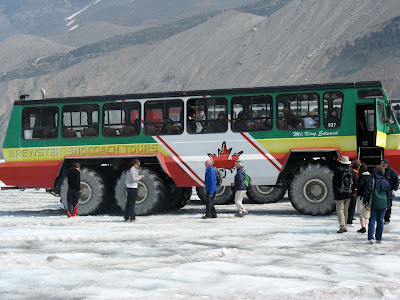

I took the 1:30 tour bus, for the 8 minute ride up to the transfer station. There, my little group of about 50 got onto snow bus. The tires on this thing are 5 foot 4 inches tall (see pic on the left).
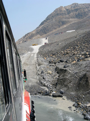


The bus took us down one of the steepest navigatable hills in the world. It was an 18%grade drop over only about 200 metres. (See pic on the left.) It was very steep and very bumpy. I had my helmet on the seat beside me, and it began sliding off. Part of the road is not paved because the glacier moves the area about a metre and half every year. Once the bus was on the ice, the climb was up hill, and not as bumpy. Interestingly, they have diverted some of the melt water into a little river, which is about two meters wide and about 15 centemetres deep. This washes the moraine debris from the tires. This debris, when deposited on the ice, absorbs heat from the sun, which contributes to making the ice melt quicker.

The ice is very dirty. When it snows on the icefield, the snow attaches to particles in the air, which are the deposited on the ice. I found out that the air was hazy because of smoke from the forest fires in BC. Even the wind blowing the ash particles onto the ice will increase its melting. In about 100 years, the Columbia icefied will be gone and in its place will be a glacier lake.

I have always wandered about the beautiful turquoise colour of many of the lakes and rivers in the Rockies. As the glacier melts, it rubs against the side of the mountains and on the valley floor. The ice slowly wears away at the bedrock, and the small particles are picked up by the melt water and eventually carried to the sea. It is the “rock flour” (small bedrock particles) that gives the water its colour. Only glacier fed lakes and river have that colour.

Anyways, enough lessons. Out little group got off the snow bus and ventured onto the ice. It was slushy ice. About three kilometres from where we stood was the head of the glacier. Downhill, the toe of the glacier seemed so small, yet longer from this perspective. Every now and then I looked down and saw a tiny river moving under a thin layer of ice beneath my feet. Around the “safe” perimeter designated for tourists, was a fast flowing, beautifully clear running river of melt water. It was mesmerizing to watch it as it slowly wound its way down into the small lake at the toe of the glacier.
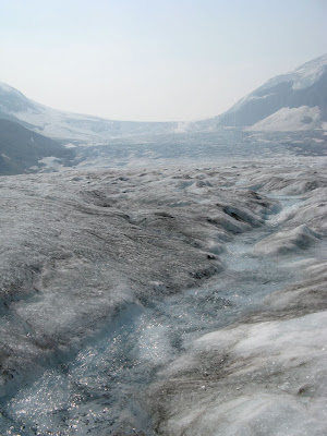

On the left is a picture of the melt water river with the head of the Columbia glacier in the distance.

It was very windy on the glacier, and as the guide later explained, this is because of the cold air created by the glacier moving down to the toe. Cold are sinks, while hot air rises. Being in the middle o the glacier means that wind created from all the ice above us, is streaming downwards, thus creating a lot of wind. On the ice, it was 2 C, not including the windchill.
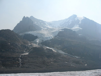
Directly to the south is the Andromeda glacier (pictured at left), which sits on top of Mount Andromeda. I thought it was a more spectacular sight than being on the icefield. A few rivers and waterfalls came from the glacier, which looked spectacular.

I was on the glacier for about 20 minutes, which doesn’t seem like a long time, but it was enough to see and do everything.

The hour and half excursion seemed to fly by and I was soon unlocking my motorcycle cover and prepping for the trip back The Crossing. Interestingly, I had parked directly in front of a moraine, which was deposited by the glacier in 1844. Since then it had retreated three kilometres. I checked the temperature at it was 16 C, which is quite a difference from the 2 C on the glacier.

The ride back to The Crossing was uneventful. I was still a bit cold, but I knew a good meal and a cold beer would soon make be feel better. I soon found out that The Crossing is nothing more than a tourist trap. If I wanted toast, it would cost me $4.83. A small coffee was $3. A bowl of soup was just over $8. I ordered fish and chips and a beer for the cheap price of $23.

The good points were that I had the quietist night and the darkest night. Even thought I slept well, I didn’t want to stay an extra second. I unpacked only what I needed for the night (a lesson I had learnt from the Howard Johnsons) and kept the rest of the stuff locked on the bike. I was ready for a quick getaway in the morning.

Finally, here's a picture of the entire icefield from the Excursion Centre, which is located beside the moraine left by the glacier in 1844. It's retreated quite a long way.


Friday, August 20, 2010

Calgary to Rocky Mountain House picture

I only took one picture on my ride into Rocky Mountain House. If you recall, I had to shorten the trip because of an impending storming. I took the photo below just as I pulled off of Hwy 2 and onto 73, which goes (straight) to Drumheller. You see those trees on the horizon where the road is? That's 11 kilometres from where I took the shot.

Fernie to Calgary pictures

I just realized that it's been a while since I posted any pictures. Here are a few from the ride on Sunday August 15.


The scenery was spectacular as I rode beside like and huge mountains.


I rode north through the Kootenay valley, which is very fertile farming country.


With this next pic, I'm trying to capture the size of one of the small mountains.


Kootenay National Park was spectacular (I know I keep using the same word, but I don't know how else to describe it). Just before I arrived in Banff, I pulled over to take a shot of Mount Rundle, which towers right above the small town.


Thursday, August 19, 2010

Quick update

Today I have an unstable internet connection and yesterday the hotel didn't provide a connection.

It's early Thursday morning and I'm in Kamloops. I'm off to Vancouver in about an hour and a half. I hope to update the blog either tonight or tomorrow morning.

Monday, August 16, 2010

Calgary to Rocky Mountain House

Day 11 - August 16, 2010

Time: 6 hours

Kilometres: 375.6

Weather:
Calgary: Sunny, 18 C at 9:15 AM
To Drumheller: 20 C - but the coldest 20 I've ever felt
Rocky Mountain House: Sunny, 29 C at 3:45

I am never, EVER, staying at another Howard Johnsons hotel again. Last night I was in a dirty room, very noisy and very stinky. I kept the door open from the time I checked in until after 11 PM. I asked for another room, but was told it would cost me more. There were only about 7 or 8 other cars , so I'm guessing that they were not full and just couldn't be bothered. Thankfully, it is the last Howard Johnsons I've book on the this trip.

I was up at 7 (I could hear the roar of the traffic through my earplugs), had a quick breakfast and then headed over to Blackfoot Motorcycles. A few weeks ago I asked people on the Adventure Riders Forum where I could get a Schumbarth C3 helmet. They are reputed to be the quietes and most comfortable helmets available - but they are not licenced for sale in Canada or the US. The helmet meets European standards, which are more stringent than DOT (for Canada and US), but for some reason Schumbarth hasn't applied for DOT certification.

The other night I had to replace my do-it-yourself soundproofing I'd done on my GMax helmet. I replaced the weather stripping and added more electrical tape to hold things in place. When I took my helmet off yesterday, I had a piece of black electrical tape stuck to my right cheek and a black mark on my left cheek. Hmm, not a fashion statement I want to make again.

To make a long story short, the C3 fit me perfectly. I couldn't carry the old helmet with me all the way back home, so I took out a few useful pieces that I may use for something or other, and left the old helmet with them. My old helmet was about twice as heavy as the C3. My chiropractor will be happy.

From Blackfoot, I headed north through Calgary and then got onto Hwy 2, which goes north into Red Deer. I turned off at 73 and headed towards Drumheller - the heart of Alberta's badlands and also famous for the dinosaur fossils. 73 is VERY straight, but that gave me a chance to take in the surroundings. The landscape is gently rolling fields. Lots of hey is harvested here, and there are also cattle ranches. I saw one alpaca ranch and one sheep farm.

The wind was rather fierce. I hadn't fought the wind like this since the storms between Regina and Swift Current.

Up in the sky to the north, clouds were gathering and heading south. I kept an eye on them as I didn't want to go through sever storms again. This time there was no shelter. The shoulder of the road was hard, but maybe a metre wide with a rumble strip taking up about a third of it. There was no way I could safely pull over and park (a kickstand on a rumble strip doesn't seem like a good idea to me).

On the horizon, I saw the ominous dark blue clouds and a couple of thermals rising. I really wanted to see Drumheller, but I decided that that would have to wait for another trip. I headed north into the storm. I'd noticed that it was coming from the north west and headed south east. If I continued into the badlands, I would most likely get hit by the worst of the weather. It didn't make sense for me to turn around, so I headed into the storm and then when I thought I was close enough, I headed west into the blue skies.

I eventually wound up back on Hwy 2 and took that very windy ride (I was doing 120 kph and I was in the slow lane) into Red Deer. It was time for a break and I stopped in at Kelsey's for a nice warm bowl of soup. The 45 minute rest was just what I needed. I got back on HWY 2 and then veered west on Hwy 11 to Rocky Mountain House.

Sorry there aren't any pictures today. It was impossible for me to pull over safely. Instead of pics, here's a map of today's route:


Tonight is a "fix-it" night. I've done a quick repair sewing job on my riding pants, did the laundry, figured how to hook up my iPod speakers for use in the new helmet, and have readied my cold weather riding gear for tomorrow's adventure in the mountains. Would you believe that my old hiking gear (rain pants, gaters, polar fleece and rain jacket) are holding up better than my motorcycle clothes? I guess it's fair to say that without Mountain Equipment Co-op, I would probably be a very unhappy rider.

Fernie to Calgary

Day 10 - Sunday August 15, 2010

Kilometres: 512.5

Time: Eight and a half hours (with stops)

Weather:
Fernie: Sunny, 11 C at 9:30 AM
Calgary: Sunny, 29 C at 6 PM

I rode through the Kootaney Valley today, which is lush farming, horse, and cattle country. Surrounding the valley are high peaks, some with year-around snow.

(I'm a day behind on my blog, so I will upload pictures tomorrow.)

I saw the Lake Columbia, the source of the Columbia River (but I think the source is the Columbia Icefield). The river is a lovely turquoise, just as I'd seen in many photos of BC's lakes and rivers.

The ride was scenic, but not very challenging as the roads were straight. It was only when I entered Kootaney National Park that the roads became more challenging and scenery changed from beautiful to spectacular. It was just unfortunate that Albertans (there were very few vehicles from BC in the park) are all used to going at least 120 kph. I'm sorry, but I want to do the speed limit and take in the sights. The speed limit, depending on how curvy the road is, was anywhere from 60 to 80 kph.

I nearly got run over by an idiot trucker. Even though I moved over for him three times to pass, he refuses and just wanted to get cozy with my tailpipe. Luckily, I found a turnout, and he whipped by me as fast and as close to me as he could.

There were a couple of areas in the park that had been decimated by forest fires. Perhaps the fires were from last year as greenery and purple flowers have spouted up rather nicely.

The fun ride was soon over and I entered Banff National Park. I was back on the Trans Canada Highway and heading east. I stopped in Banff for gas. It's a pretty little town but it has too many tourists in it for me to stay longer than necessary.

From Banff it was clear ride through to Calgary. I really didn't want to leave the mountains behind. But tomorrow is another day ... and I'm not finished with the mountains.

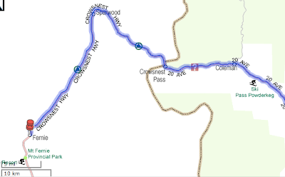
Here's the route I took today:


Sunday, August 15, 2010

Fort MacLeod to Fernie

Day 9 - Saturday August 14, 2010

Time: six hours, 50 minutes (lots of stops)

Kilometres: 170.5

Weather:
Fort MacLeod: Overcast but bright, 20C at 10 AM
The Crow's Nest: Partly cloudy, 18 C at noon
Fernie: Partly cloudy, 26 C at 5 PM

I have loads of pictures to show you, which I think will do much better than a written description. After checking into the Red Coat Motel (RCMP inspired) I went tof ra walk through historical Fort MacLeod. It took maybe 15 minutes for me to walk along main street and back. Most of the buildings are from 1903 to 1909. Not very historical, but I guess it is as the west really wasn't settled at that point.

One street over, and running parallel to Main Street is the actual fort. It was the training area for the RCMP (at that time I think they were still called the Northwest Mounted Police) in the west before the base operations moved east to Regina. The fort is a simple wooden pallisade. I didn't bother to go in as it was after 6 and it was most likely closed for the day.

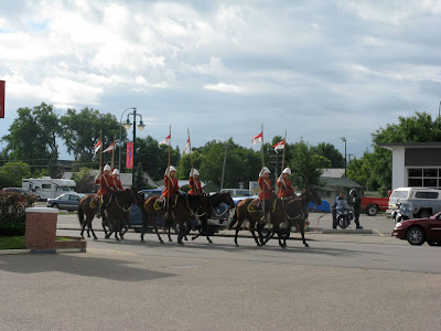
I got up early in the morning and began packing my bike. As I was playing with the bungee chords, I
heard the clip-clop of hooves. It took a second for the sound to register. When I looked up, the RCMP
was going by the hotel. Later on, as I pulled out of town, I purposely rode by the fort and found out that they do the Musical Ride twice a day, with the first performance at 10. I'd just
missed it.


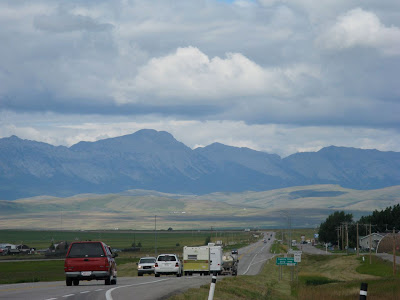
I headed west, eagerly waiting for my first glimpse of the mountains. I could clearly see the foothills, but not the actual mountains. One of things on my "to see" list was the wind farm at Pincher Creek. I believe it is the largest in Canada, but I guess most of the are over the hills and not visible
from the Crowsnest Highway.
Nonetheless, I got a good shot of them along the top of a ridge. I think that the wind farm near Kincardine, Ontario is much bigger, but it is much windier in Pincher Creek.

From just before reaching Pincher Creek, I could see both the foothills and the Rockies. I was so looking forward to this part of the trip.

Just up the highway from Pincher Creek is Lundbreck. I was now getting into the mountains. I'd been having big problems with my helmet speakers over the last few days, but I finally got them working for today's ride. Just as I rode through Lundbreck, Nightwish's Higher Than Hope was playing. It's a real juxtaposition to listen to symphonic goth while riding through the foothills and the mountains. So out of place.


My first stop was at the ruins of a coal mining operation. The stone washhouse foundations and first floor walls were still in tact. The tipple was long gone, but I could see where the footing were. Signs along the way told the story of how coal was mined in the area. I looked to the west and over one a hill I saw the peak of a huge stone mountain.

I turned a corner and came to the sign I'd bee waiting to see for such a long time: I was in the Crowsnest Pass

I soon rounded a corner and had a spectacular view of the area. It actually made my chin drop, but there wasn't a turnout on the road, so sorry, no pic.

My first stop was in Bellevue. I grabbed a quick sandwich and then headed for the mine, where I was given a miner hardhat and lamp. At the mouth of the coal mine was a thermometer. It was 2C. I was glad that I was wearing five layers of clothes. The first thing that hit me was the smell: sulphur. And, man, was it ever strong. the next thing that hit me was the very sudden temperature drop. I was only about three metres in the mine and it was close to freezing. The guide took a small group of us tourist down the main shaft of the mine. Because the shaft followed the vein of coal, the floor in level (but slopping downwards) but the ceiling and walls are not. The thick wooden beams holding up the ceiling are at angle and it really gave me the impression of being in a fun house at the midway. We were told to look at the floor if we
started to get disoriented. I was down the mind for about an hour. To me it was worth the $10,
but some people definitely would not like it.

In the parking lot was a couple of coal railroad cars. I reached into one of the cars and now have a nice, shiny (means it's very high grade) piece of coal as a souvenir of my visit to the Corwsnest.

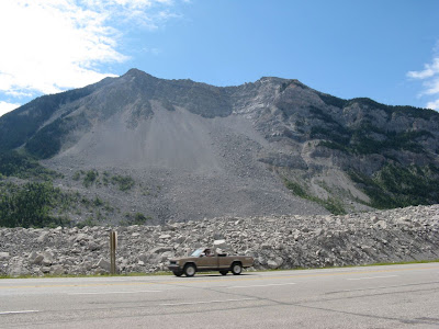
The most imposing feature of the Crownest is Turtle Mountain. That was the mountain I had seen from my the ruins of the wash house. The Indians called it Turtle Mountain because they believed it moved. Of course the white guys at the time thought that was a bunch of crap. They build the coal mining town of Frank at the base of Turtle Mountain. Then early one morning in April 1903, the mountain moved. Half the face came off and slid through the town of Frank and across the valley floor. Seventy people were killed. The miners working that night had to tunnel their way out.

Seeing the rock slide in photos doesn't begin to show the enormity of the event. Some of the rocks, I guess I should call them boulders, are the size of small house. Some of them were bigger than my 750 square foot apartment.

Here are two pictures. The first is of the Turtle Mountain. You can clearly see the area that gave way. The second picture was taken from the same spot, but I've turned around to show you how far the slide went and how big some of the smaller boulders were.
I'd heard about the slide years ago, and this was one of my main reasons for riding through the pass.

As I have known the story of the Frank Slide for years, there was no reason for me to go into the interpretive centre; but I went up there to get a broader view of the area.

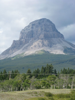
I can't end off today's post with showing you a picture of the mountain the pass was named after:


It was starting to get late in the afternoon, so I decided to call it a day. I had about an hours ride into Fernie, and I was looking forward to going for a swim


Saturday, August 14, 2010

Swift Current to Fort MacLeod


Day 8 – Friday August 13, 2010

Time: 7 hours, 45 minutes (including numerous stops)

Kilometres: 459.9

Weather:

Swift Current: Overcast and foggy, 12 C at 10 AM

Fort MacLeod: Overcast, periods of rain, 11 C at 5:30 PM

Last night was a Hotel California night. You know, “You can check out any time but you can never leave.” It was a bit creepy. I check in just after 5 PM and I was the only guest. The pool was closed, the restaurant was closed and the place looked like it was ready for a wrecking ball. Someone should put this Howard Johnsons hotel out of its misery. It was the second worst hotel I’ve ever stayed in. The only reason I didn’t get on my bike and go to anther hotel is because I was too tired, too wet, and too fed up with being on the bike. Enough was enough and I needed to relax.

The place wound up having about a dozen guests … many of them watching the Saskatchewan Roughrider take on some other team. These people are really into their football. They are probably as fanatic as Canadiens fans.

Anyway, I got up the morning and just wanted to hit the road and get the hell out of Dodge. I packed everything up and was ready to throw my bags on the bike. But then I looked outside and knew that today’s weather was going to scrap more of my tourist plans. It was rainy and foggy and I couldn’t see more than 5 kilometres in front of me.

At my first gas stop, I met the German guy from yesterday’s storm. He’d also stopped in Swift Current. He gave me his pen (most people have business cards) and invited me for a coffee when I go through Lilloot. He says he has the only radiator repair shop in town.

The fog didn’t lift. In fact, it sunk even closer to the ground as I rode westward. The plan was to loop south and ride through the Cypress Hills and then meet up with T’Can near the Alberta border. When I got to the turn off, visibility was only about 3 kilometres. There wasn’t any point in going south if I couldn’t see anything, so I continued westward. (On the following map, my route would have been to head south on hwy 37 then west on 13 (not on the map) and then north on hwy 21.)

By the time I hit the Alberta border the fog was lifting, but it was raining and the wind was picking up. I didn’t even stop at the “Welcome to Alberta” sign because I was in no mood to prolong the ride.

The further west I went, the worse the weather. Just before Medicine Hat, the sky opened up with a good soaking. I kept riding as I could see the road. It was a heavy concentration day, but even so, my mind wandered. I just haven’t been eating properly since I started the trip. It seems that everywhere I go the most convenient places to eat are Subway and Tim Hortons. I began to crave real food. Fruit, vegetables, good protein that isn’t stuffed between two pieces of bread. My list grew to salmon on a plank with a salad, cheese quiche with broccoli and corn on the side. I hadn’t had a banana or grapes in over a week. I pulled into Medicine Hat for lunch, found a Kelsey’s and they coincidentally have salmon served with a salad for lunch.

Some of the smaller storms, I contended with, but when I saw a big one, I knew to pull on the throttle and get into the next town. The next pull over was in Tabar. I pulled into a Tim Hortons, ordered a coffee and a muffin and watched while two storms flew over me.I quickly got back on the road, but as my hands were cold, I wore both my insulated waterproof gloves and the rain-off gloves. That helped a bit. I didn’t get very far before the skies started to look menacing again. At least it didn’t look as bad as what I’d gone through yesterday, but the wind was wicked. I was fighting with the bike all the time. At one point I thought I should pull over, but the next town was only a kilometre away and I could still see.

I pulled into Bow Spring, got gas and waited for another storm to pass. They were sweeping down from the north. I could see them coming and it was a bit of a game to judge whether I could make it to the next town before the next storm hit.

While in Taber, I saw what I fist thought was a family of Mennonites, simply because the way they were dressed. They were clearly farmers, but I didn’t think Mennonites were in Alberta and I know they don’t frequent Tim Hortons. When the family talk amongst themselves, I didn’t recognize the language. Perhaps they are Dukeabours (sp?)

The ride from Taber to Lethbridge wa pretty much the same: strong wind and quick, messy storms rolling through. I kept my eye open for downbursts, but thankfully, didn’t see any.

To give you an idea of how strong the wind was, I had to constantly lean the bike to the right to keep it upright. When I passed a stand of trees (not that often) or a train on the tracks that run parallel to the highway (more often than trees) or grain elevator ( every few kilometres) the wind would cease for a second, and then whip around and blow from my left., or sometimes, I’d just be sheltered and it was like normal riding. It was one of the best upper body workouts I’ve had in a long time.

Just outside of Lethbridge, I rode over a butte and saw the foothills of the Rockies. At first I wasn’t sure if I was looking at the foothills or storm clouds, but the closer I got, the clearer the outline became. I was almost at the end of my prairie journey.

I pulled into Fort MacLeod, check into the motel, unpacked my bags and had a quick shower. I needed to warm up (what else is new?) and feel clean after such a rotten day on the road.

The weather started to clear up a bit. It was still cold and windy, but at least it wasn’t raining. I walked down main street and found that one the street behind me is the actual fort. I hope to have time in the morning to quickly visit it.

I am so looking forward to tomorrow’s planned activities. The four things I’ve planned have been on my “to do” list for several years. See the Hillcrest mine site, go down the Bellevue coal mine, see the town (or what’s left of the town) of Frank, and then ride through the Crow's Nest Pass.