Wednesday, August 25, 2010

Columbia Icefields to Kamloops

NOTE: I've been trying to catch up, so I'll post days 13 and 14 today, and add the pic tomorrow along with the write ups for days 15 and 16.

The Columbia Icefields to Kamloops

Day 13 – Wednesday August 18, 2010

Kilometres: 541.1

Time: Seven and half hours, including stops

Weather:

The Crossing (hwys 11 & 93): Light smoky, bright, 10 C at 8:30

Lake Louise: Sunny, 18 C

Golden- Hot and sunny, 28 C

Kamloops – Hazy, 40 C

I couldn’t get going quickly enough. I really felt ripped off with my expensive room that wasn’t anything special. I should have stayed in Lake Louise. I know that hindsight is 20/20.

I packed up quickly, bought a small coffee ($3.13 please) and ate a Power Bar in my room. On my way back from the cafeteria, I met a little chipmunk scurrying around the rocking in front of my hotel room. I watched him almost slither in, out and around the rocks. It moved some fast that it was difficult to see distinct movements.

I sat in my room with the door open eating my breakfast when all of a sudden the chipmunk came inside my room to see what was in there. It looked so cute as it came to a sudden stop, standing up, and saying to it self, “Nope, I don’t want to be here,” and running back outside again. That was really, really funny and cute.

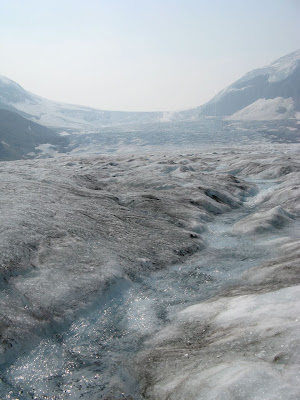
I was soon on my bike and riding south towards Lake Louise. It was a crisp morning and wonderful day to be on the road. I stopped a couple of times to take picture of snow-capped mountains (I’m surrounded by them) and pristine lakes. Everywhere I looked it was a candidate for a postcard or calendar. This part of the mountains is spectacular because of the contrasts.

Here are a couple of pictures from the area between The Crossing and Lake Louise:


I’m not into tourist traps at all, but I had to stop at Lake Louise for gas, which was about 10 cents a litre cheaper than it was at The Crossing. I didn’t go too far into town because it was apparent that that it was all set up for tourists, much like Banff is. That’s not what I’m riding these roads to see, so I was soon on the highway and heading towards Golden.

It started to heat up as I descended into the valley. I had five layers on and I was soon starting to roast. Somewhere around there I moved into the Pacific Time Zone, and around noon Pacific Time I stopped in Golden for a quick sandwich at Tim Hortons.

After lunch, I took off a couple of layers and continued on. I didn’t want to change from jeans into my cycling shorts because I knew I had to go through Roger’s Pass. The last time I was there it was the end of August and there was snow at the side of the road. I’m not doing snow in spandex.

Roger’s Pass was so neat. The government has built avalanche tunnels. There must be loads of avalanches in the area. The tops of the tunnels have a few trees on them, but the tunnel is obviously an entirely man-made structure. They the top of the tunnel slops enough so that rocks, or more likely snow, just tumble over the tunnel and into the valley below. Columns hold up the outside wall of the tunnel, so I could easily see outside into the valley. It also let in lots of light, so they really didn’t need to light the tunnels during the day.

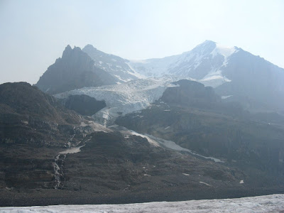
I think I went through about four or five of these tunnels before reaching a turnout after going through the Pass. I turned around I saw what I guess to be Roger’s Mountain. Here’s a pic of the view:


There wasn’t any snow at the side of the road, but there was about 300 metres up side of the mountain. I was glad I left my jeans on.

It was all down hill after that, and the further I went down, the hotter it became. I was soon in Revelstoke, where I was desperate for a washroom so I could change. Just outside of town was a turnout with an outhouse. I quickly unpacked my shorts and grabbed a tank top. I kept my cooling bandanna in reserve in my tank bag.

The road between Revelstoke and Kamloops is so scenic. It’s all lakes and mountains. In Salmon Arms they have quite a pleasure craft interest.

The further west I went, the hotter and hazier it became. I’ve hardly ever felt this way before while riding: “Am I there yet?” It really seemed to take forever to get to Kamloops. I don’t know why either, because I was really enjoying the scenery, but it just seem like a really, really long day.

When I got to the hotel, the air was hazy with smoke, but it wasn’t anything major. But, boy was it every hot. It was a toasty 40 C. I’d hate to know what it was if the hazy wasn’t there and the sun was at full force.

Checking into the hotel was not as straight forward as I’d thought. There seemed to be some discussion about my reservation. A gentleman named Freddie, who I soon found out was the owner, gives motorcycle riders a rather generous discount. He knocked off $30. As we began talking, he gave me a can of beer (I can’t drink and ride) and then gave me a $10 gift certificate at the local pub. He then took my tank bag and helmet and walked over to my ground floor room where he put a orange pylon in the spot in front so I had reserved parking.

I took his suggestion and went to pub, had a good meal and then went back to the hotel and had a beer. It was a perfect evening, with the hot desert breeze blowing from behind the hotel, I sat outside and took in the sights of the junipers and sage growing along the side of the highway. What a perfect way to end the day.

Saturday, August 21, 2010

Rocky Mountain House to the Columbia Icefields

Day 12 – Tuesday August 17, 2010

Kilometres: 293.1

Time: Seven and half hours, including stops

Weather:

Rocky Mountain House: Overcast, 12 C at 9 AM

The icefields: smoky, 2 C on the glacier, at the excursion centre: smoky and 16 C

The Crossing (hwys 11 & 93): Light smok, bright, 24 C at 4:30

It rained overnight so that cleaned a lot of bugs off of my bike as I didn’t put the cover on. I had the best breakfast of the trip: cheese omelette, cinnamon roll, a banana and coffee. I’m gain weight from the processed, salty food, and I am starting to feel a bit sluggish.

Last night I got all my cold weather gear unpacked and ready for the morning. It was so chilly that I simply decided to wear everything at the beginning of the trip to save pulling over later on. It was a good idea, as I was soon riding through the Rocky Mountains Forest Reserve. The road was a bit twisty, which made it fun to ride, and the hills slowly got larger. I saw my first wildlife here. A coyote stood looking back up the road behind me. It was just beyond the ditch at the side of the road. I actually thought it was a cross fox, but it had white on it. Later, when I was looking in a gift store, I saw a postcard that looked exactly like the canine I’d seen.

The weather started to close in – or I should say, I met the weather. The further I rode, the high the hills, and because of the low cloud cover, I was riding into clouds. No, this wasn’t fog, as fog sits close the ground. When I rode into valleys, the visibility cleared up. At one point in the ride, which lasted about 20 minutes, I crawled along at about 60 kph because I could see less than 250 metres in front of me. I know that for a fact, because several times I saw signs saying, “Right lane ends in 250 metres.” I couldn’t see that far ahead of me to see the merging lanes.

Gas was a huge concern, as there are few towns out in this area. I stopped at a little place called Nordegg, which is an old coal mining town (now offering ghost town tours!). This looked like the last gas stop until who-knows-when. But the best sign I read today was at the Nordegg city limits. It said, “No hunting in town.” I topped up my tank ($3.50) and headed for Banff National Park.

At this point I was beginning to freeze. I had five layers on, including my heavy, winter hiking socks and hiking boots. But my feet and hands were cold and so was my nose. When I got to the toll gate at park’s entrance I stopped and put on my rain-off gloves, hoping that they would offer a bit more protection from the wind.

I would love to go back to Blackfoot Motorcycle in Calgary as they carry all sorts of clothing that is not available in Toronto. I guess that is another reason for a return trip.

I saw a doe at the side of the rode. It was too close to the rode for comfort, and I hoped that it didn’t feel like wandering in front of me. I pulled in my clutch and revved my engine, hoping it wouldn’t come in my direction. Like the old saying goes, the deer froze, and I rode by. The one thing that really struck me about the doe was how large its black nose was. It just looked out of proportion.

I was soon at highways 11 and 93, known as the Saskatchewan Crossing, or simply The Crossing. It contains one complex with a motel, a gift store, gas, and restaurant. All owned by the same people. I pulled in for gas, and was shocked at the price. Elsewhere in Alberta, gas was between 93 and 95. Here it was 1.28. Nonetheless, I topped up the tank, and headed north to the Columbia Icefield.


On the left is a picture of the road I'd just ridden ... and I still wasn't at the top of the Icefields Parkway. The haze is from the forest fires.

The mountains on either side of 93 (also called the Icefield Parkway) are much different than the ones to the south. These are higher in elevation, seem to have sharper peaks, and many of these mountains are snow covered in areas. Because of their height, the treeline is clearly visible. I stopped at few turnouts on the way north. I saw Bridal Veil Falls, where the water comes from a huge height (probably over 9,000 feet).

At one point, I saw cars on both sides of the road pulling over. I pulled over and grabbed my camera. About three car lengths ahead of me and in the bushes the other side of the road ditch was a big brown bear feeding on berries. I snapped off a few quick pictures and left. I just don’t trust large animals that can run faster than me, and have very sharp claws.

There were a couple of steep parts in the roads, and it was at times very twisty. At some point the sun tried to shine through, but it wasn’t clear sunshine. As the heavy cloud cover dissipated, the sky still didn’t seem clear.

I was soon at the Icefield, where I show my pre-paid ticket to both the two hour hike and tothe snow bus excursion. But my timing was off. I could do one but not the other as the times overlapped. If I tried to do both, I wouldn’t get back to my motel (at The Crossing) until about 7 PM. That was waaaay too late for me, even though it would still be light. I opted to do the snow bus and then was given a full refund for the hike. Yup, another reason to come back this way again.


I took the 1:30 tour bus, for the 8 minute ride up to the transfer station. There, my little group of about 50 got onto snow bus. The tires on this thing are 5 foot 4 inches tall (see pic on the left).


The bus took us down one of the steepest navigatable hills in the world. It was an 18%grade drop over only about 200 metres. (See pic on the left.) It was very steep and very bumpy. I had my helmet on the seat beside me, and it began sliding off. Part of the road is not paved because the glacier moves the area about a metre and half every year. Once the bus was on the ice, the climb was up hill, and not as bumpy. Interestingly, they have diverted some of the melt water into a little river, which is about two meters wide and about 15 centemetres deep. This washes the moraine debris from the tires. This debris, when deposited on the ice, absorbs heat from the sun, which contributes to making the ice melt quicker.

The ice is very dirty. When it snows on the icefield, the snow attaches to particles in the air, which are the deposited on the ice. I found out that the air was hazy because of smoke from the forest fires in BC. Even the wind blowing the ash particles onto the ice will increase its melting. In about 100 years, the Columbia icefied will be gone and in its place will be a glacier lake.

I have always wandered about the beautiful turquoise colour of many of the lakes and rivers in the Rockies. As the glacier melts, it rubs against the side of the mountains and on the valley floor. The ice slowly wears away at the bedrock, and the small particles are picked up by the melt water and eventually carried to the sea. It is the “rock flour” (small bedrock particles) that gives the water its colour. Only glacier fed lakes and river have that colour.

Anyways, enough lessons. Out little group got off the snow bus and ventured onto the ice. It was slushy ice. About three kilometres from where we stood was the head of the glacier. Downhill, the toe of the glacier seemed so small, yet longer from this perspective. Every now and then I looked down and saw a tiny river moving under a thin layer of ice beneath my feet. Around the “safe” perimeter designated for tourists, was a fast flowing, beautifully clear running river of melt water. It was mesmerizing to watch it as it slowly wound its way down into the small lake at the toe of the glacier.


On the left is a picture of the melt water river with the head of the Columbia glacier in the distance.

It was very windy on the glacier, and as the guide later explained, this is because of the cold air created by the glacier moving down to the toe. Cold are sinks, while hot air rises. Being in the middle o the glacier means that wind created from all the ice above us, is streaming downwards, thus creating a lot of wind. On the ice, it was 2 C, not including the windchill.

Directly to the south is the Andromeda glacier (pictured at left), which sits on top of Mount Andromeda. I thought it was a more spectacular sight than being on the icefield. A few rivers and waterfalls came from the glacier, which looked spectacular.

I was on the glacier for about 20 minutes, which doesn’t seem like a long time, but it was enough to see and do everything.

The hour and half excursion seemed to fly by and I was soon unlocking my motorcycle cover and prepping for the trip back The Crossing. Interestingly, I had parked directly in front of a moraine, which was deposited by the glacier in 1844. Since then it had retreated three kilometres. I checked the temperature at it was 16 C, which is quite a difference from the 2 C on the glacier.

The ride back to The Crossing was uneventful. I was still a bit cold, but I knew a good meal and a cold beer would soon make be feel better. I soon found out that The Crossing is nothing more than a tourist trap. If I wanted toast, it would cost me $4.83. A small coffee was $3. A bowl of soup was just over $8. I ordered fish and chips and a beer for the cheap price of $23.

The good points were that I had the quietist night and the darkest night. Even thought I slept well, I didn’t want to stay an extra second. I unpacked only what I needed for the night (a lesson I had learnt from the Howard Johnsons) and kept the rest of the stuff locked on the bike. I was ready for a quick getaway in the morning.

Finally, here's a picture of the entire icefield from the Excursion Centre, which is located beside the moraine left by the glacier in 1844. It's retreated quite a long way.


Friday, August 20, 2010

Calgary to Rocky Mountain House picture

I only took one picture on my ride into Rocky Mountain House. If you recall, I had to shorten the trip because of an impending storming. I took the photo below just as I pulled off of Hwy 2 and onto 73, which goes (straight) to Drumheller. You see those trees on the horizon where the road is? That's 11 kilometres from where I took the shot.

Fernie to Calgary pictures

I just realized that it's been a while since I posted any pictures. Here are a few from the ride on Sunday August 15.


The scenery was spectacular as I rode beside like and huge mountains.


I rode north through the Kootenay valley, which is very fertile farming country.


With this next pic, I'm trying to capture the size of one of the small mountains.


Kootenay National Park was spectacular (I know I keep using the same word, but I don't know how else to describe it). Just before I arrived in Banff, I pulled over to take a shot of Mount Rundle, which towers right above the small town.


Thursday, August 19, 2010

Quick update

Today I have an unstable internet connection and yesterday the hotel didn't provide a connection.

It's early Thursday morning and I'm in Kamloops. I'm off to Vancouver in about an hour and a half. I hope to update the blog either tonight or tomorrow morning.

Monday, August 16, 2010

Calgary to Rocky Mountain House

Day 11 - August 16, 2010

Time: 6 hours

Kilometres: 375.6

Weather:
Calgary: Sunny, 18 C at 9:15 AM
To Drumheller: 20 C - but the coldest 20 I've ever felt
Rocky Mountain House: Sunny, 29 C at 3:45

I am never, EVER, staying at another Howard Johnsons hotel again. Last night I was in a dirty room, very noisy and very stinky. I kept the door open from the time I checked in until after 11 PM. I asked for another room, but was told it would cost me more. There were only about 7 or 8 other cars , so I'm guessing that they were not full and just couldn't be bothered. Thankfully, it is the last Howard Johnsons I've book on the this trip.

I was up at 7 (I could hear the roar of the traffic through my earplugs), had a quick breakfast and then headed over to Blackfoot Motorcycles. A few weeks ago I asked people on the Adventure Riders Forum where I could get a Schumbarth C3 helmet. They are reputed to be the quietes and most comfortable helmets available - but they are not licenced for sale in Canada or the US. The helmet meets European standards, which are more stringent than DOT (for Canada and US), but for some reason Schumbarth hasn't applied for DOT certification.

The other night I had to replace my do-it-yourself soundproofing I'd done on my GMax helmet. I replaced the weather stripping and added more electrical tape to hold things in place. When I took my helmet off yesterday, I had a piece of black electrical tape stuck to my right cheek and a black mark on my left cheek. Hmm, not a fashion statement I want to make again.

To make a long story short, the C3 fit me perfectly. I couldn't carry the old helmet with me all the way back home, so I took out a few useful pieces that I may use for something or other, and left the old helmet with them. My old helmet was about twice as heavy as the C3. My chiropractor will be happy.

From Blackfoot, I headed north through Calgary and then got onto Hwy 2, which goes north into Red Deer. I turned off at 73 and headed towards Drumheller - the heart of Alberta's badlands and also famous for the dinosaur fossils. 73 is VERY straight, but that gave me a chance to take in the surroundings. The landscape is gently rolling fields. Lots of hey is harvested here, and there are also cattle ranches. I saw one alpaca ranch and one sheep farm.

The wind was rather fierce. I hadn't fought the wind like this since the storms between Regina and Swift Current.

Up in the sky to the north, clouds were gathering and heading south. I kept an eye on them as I didn't want to go through sever storms again. This time there was no shelter. The shoulder of the road was hard, but maybe a metre wide with a rumble strip taking up about a third of it. There was no way I could safely pull over and park (a kickstand on a rumble strip doesn't seem like a good idea to me).

On the horizon, I saw the ominous dark blue clouds and a couple of thermals rising. I really wanted to see Drumheller, but I decided that that would have to wait for another trip. I headed north into the storm. I'd noticed that it was coming from the north west and headed south east. If I continued into the badlands, I would most likely get hit by the worst of the weather. It didn't make sense for me to turn around, so I headed into the storm and then when I thought I was close enough, I headed west into the blue skies.

I eventually wound up back on Hwy 2 and took that very windy ride (I was doing 120 kph and I was in the slow lane) into Red Deer. It was time for a break and I stopped in at Kelsey's for a nice warm bowl of soup. The 45 minute rest was just what I needed. I got back on HWY 2 and then veered west on Hwy 11 to Rocky Mountain House.

Sorry there aren't any pictures today. It was impossible for me to pull over safely. Instead of pics, here's a map of today's route:


Tonight is a "fix-it" night. I've done a quick repair sewing job on my riding pants, did the laundry, figured how to hook up my iPod speakers for use in the new helmet, and have readied my cold weather riding gear for tomorrow's adventure in the mountains. Would you believe that my old hiking gear (rain pants, gaters, polar fleece and rain jacket) are holding up better than my motorcycle clothes? I guess it's fair to say that without Mountain Equipment Co-op, I would probably be a very unhappy rider.

Fernie to Calgary

Day 10 - Sunday August 15, 2010

Kilometres: 512.5

Time: Eight and a half hours (with stops)

Weather:
Fernie: Sunny, 11 C at 9:30 AM
Calgary: Sunny, 29 C at 6 PM

I rode through the Kootaney Valley today, which is lush farming, horse, and cattle country. Surrounding the valley are high peaks, some with year-around snow.

(I'm a day behind on my blog, so I will upload pictures tomorrow.)

I saw the Lake Columbia, the source of the Columbia River (but I think the source is the Columbia Icefield). The river is a lovely turquoise, just as I'd seen in many photos of BC's lakes and rivers.

The ride was scenic, but not very challenging as the roads were straight. It was only when I entered Kootaney National Park that the roads became more challenging and scenery changed from beautiful to spectacular. It was just unfortunate that Albertans (there were very few vehicles from BC in the park) are all used to going at least 120 kph. I'm sorry, but I want to do the speed limit and take in the sights. The speed limit, depending on how curvy the road is, was anywhere from 60 to 80 kph.

I nearly got run over by an idiot trucker. Even though I moved over for him three times to pass, he refuses and just wanted to get cozy with my tailpipe. Luckily, I found a turnout, and he whipped by me as fast and as close to me as he could.

There were a couple of areas in the park that had been decimated by forest fires. Perhaps the fires were from last year as greenery and purple flowers have spouted up rather nicely.

The fun ride was soon over and I entered Banff National Park. I was back on the Trans Canada Highway and heading east. I stopped in Banff for gas. It's a pretty little town but it has too many tourists in it for me to stay longer than necessary.

From Banff it was clear ride through to Calgary. I really didn't want to leave the mountains behind. But tomorrow is another day ... and I'm not finished with the mountains.

Here's the route I took today: