Showing posts with label Southern Ontario. Show all posts

Monday, September 13, 2010

Getting my Full M Licence

One of the first things I did when I returned from the Big Trip was book my exit test to get my full M (motorcycle) licence. Today was the big day.

I read the ministry's motorcycle handbook this morning as a quick refresher. But there is no use studying for this test as it is all about riding. I knew beforehand that highway riding is part of the test, as is riding through both residential and business areas of a city.

I think over the course of the summer I'd put in enough practice and now it was time to find out if I had the skills needed to pass the test. All the test centres were booked and the closest one was in Stoney Creek. I wasn't going to wait and hope for more dates to open up, so I took the opportunity while I had it.

The first hurdle for me was riding over the Burlington Skyway. The huge bridge is sometimes closed because of strong winds, and that is the reason I'd avoided going over it. Today was another nice warm and sunny day, so I knew wind wouldn't close the bridge.

I arrived just in time for my 2:45 appointment. I filled out the required papers and then met the examiner who showed me how to hook up the ear piece in my helmet. Two examiners were going to follow me in their car and give me directions as I ride.

My only concern was the helmet that I'd picked up in Calgary. It meets European standards, which I understand exceed DOT standards. However, the helmet has not been DOT tested so it is illegal for me to wear in Ontario. I didn't want to show up for the test wearing a safer, yet non-DOT helmet and have them tell me I can't ride the test. As a precaution, I used several bungee cords to hold my first cheap, $80 DOT approved helmet to the back seat.

They didn't ask about the helmet and I didn't say anything, so off we went. The test was about half an hour long, and it covered highway, residential and business zones. I passed without a problem. So what's the difference between having an M2 and a full M licence? I can now drink and ride. Hmmm, there is just something so very wrong with this. The government should really re-think this system.

So, I received my M1 licence in June 2008, and my M2 licence on September 17, 2008. Because I took a rider training course back in June 2008, I was eligible to ride my m2 exit test in June 2010. Instead, I hit the road and took the test after I knew I would pass it with flying colours. What better training ground than riding through five provinces?


Saturday, September 11, 2010

Ride through Huntsville

Kilometres: 547.3

Time: seven and a half hours, including stops

Weather: Sunny, 20 C at 10 AM

What a beautiful day for a ride. It’s sunny, warm and perfect riding weather. I had only a light jacket over my riding gear, but of course I had all my rain gear with me just in case.

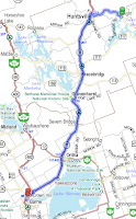
I’d heard about the twisty roads up north towards Huntsville and headed east out of Toronto along the 401. It was a bit trafficy, but lighter than I expected. I rode from one highway to the next and finally put the speedy traffic behind me as I rode off the 115 onto 35.

Highway 35 was my destination, as I’d heard that it is really twisty the further north you ride. The area around Lindsay is dotted with pastures of horses and cows. There are also few farms, but the harvest, for the most part, has be brought in.

The ride from Lindsay to Coboconk was a bit twisty, but overall it was just a nice quiet ride. It felt good to be out of the city traffic again. After spending all of August on the open road, I discovered that I really missed just getting away from all the cars. This quiet ride is probably as good as it gets in Southern Ontario.


I’d been up this way a few times before, but never all the way to the top of 35. I just had to stop the Kawartha Dairy in Minden.That has to be the best hard ice cream I’ve ever had and I always stop there if I’m in the area. I washed down my homemade egg salad sandwich with a double scoop of chocolate cookie dough ice cream. I think I could feel the calories settling in as I continued to ride north.

The road north of Dorest had recently been paved, so I knew not to lean too much as I road. After the Rockies, this was a bit disappointing, but at least I was gliding through corners, moving my weight on the bike and doing some real riding.

Unfortunately, that section of the ride was too short and time was running out, so I didn’t have time to do it again unless I also wanted to retrace my ride back to Toronto. I opted for a new road, hoping for some more twisties.


The ride into Huntsville brought me back to civilization. I passed by Dearhurst Inn where the G8 Summit was held in June. No barbed wired now. I turned on my GPS just before getting to Huntsville. I really didn’t want to get turned around and lost in the town. There were so many tourists and cottage people (this means horrible Ontario drivers) there that I just wanted to get out as soon as possible - and without getting hit.

I quickly found Highway 11 and headed south towards Barrie. Highway 11 is typical two-lane highway, so that means there is little opportunity to take in the scenery unless I want to get run over. Just south of Hawkstone, I looked over at some pastureland. I was gobsmaked because there were bison grazing in the field. I’d been all over the Prairies; I’d run my hands through thick bison hides, I’d walked on bison rugs, but I had not been able to find one living bison. And here they are; not in Manitoba, where the bison is on the provincial coat of arms, but in Southern Ontario. There is something so wrong about all of this.

Highway 11 merges with Highway 400 near Barrie. As I road home I realized that I was riding the same road I’d ridden last Satruday, at almost the exact same time. Today, I was 15 minutes earlier than I had been last week. What a difference seven days makes. The weather is better today, but I must admit, I’d rather be heading out on another adventure than returning home.

But the season isn't over yet and I hope to put a few more good trips under my wheels before I have to put the 950 away for the year.

Saturday, September 4, 2010

Blind River to Toronto

Day 30 – Saturday September 4, 2010

Kilometres: 569.4

Time: 7 and a quarter hours (including stops)

Weather:

Blind River: Light rain, 9 C at 9 AM

Barrie: Steady rain, windy, 12 C at 3 PM

Toronto: Overcast, windy, 17 C at 4:15 PM

I don’t think I will ever warm up. I heard that Toronto was in the middle of heat wave a few days ago. I guess I brought the cool weather with me all the way from Tete Jeuane.

But let’s start from the beginning of the day. Last night I had put the left over pizza in the fridge with the intention of have it for breakfast this morning. Unfortunately, I forgot to check the temperature in the fridge and discovered that the pizza was frozen solid. I packed up my bike, put on all four layers of clothing and hit the road.

I stopped at the Tim Hortons in Espanola for a quick breakfast. I must have arrived during rush hour, as it was quite busy. May of the people were heading south to catch the ferry to Manitoulin Island. I briefly thought out doing that too, but decided against. The ride through the First Nations’ hunting ground south of Tobermory is a really boring ride with hardly anywhere to stop if the weather turns bad.

The ride around Georgian Bay was uneventful. However, the rain was slowing becoming more steady and harder.

Around one o’clock I pulled into service centre. The rain was really coming down and I needed a bit of break. I was also hoping that the weather would improve after I had a bight to eat. I was so fortunate that there is a Lick’s Burgers at the service centre. I really have missed their nature burgers. Having the burger made me realize that I was back in familiar territory. The Big Trip was nearly over and I was now riding the roads that are in my backyard.

I started to look back on how different the people are, not only in each province, but also in different parts of the same province. The one thread that was common to everyone I met was their friendliness. Most people wanted to talk, help, offer suggestions, or just pass the time with me. Some people, like the woman who invited me into her car during the sever thunderstorm in Saskatchewan, went out of their way when they didn’t have to.

Everyone was friendly, which is something I am very grateful for.

Here are my observations about the some of the provinces.

Without a doubt, Ontario has the worst drivers. It’s not the speeding that bothers me, it’s the “me first” mentality that endangers everyone on the road.

I’ll always remember the Manitoba for the golden fields of wheat and sunflowers. Even though it’s a Prairie province, it’s not all flat. Although the roads are very straight in the forests in the eastern part of the province have, riding through woods was very tranquil.

If you want to buy an old car, go to the middle of Saskatchewan. Many of the farmers have old – think 1940s – cars just sitting there. I met a number of fans from Rider Nation, who were really nice people. Now I really understand how the word “fan” originated from the word “fanatic.”

Alberta drivers are all speed freaks. Not that they are bad drivers, they’re just fast drivers.

BC is full of friendly people, even in Vancouver. The roads were twisty through the mountains and I don’t think I can get back there soon enough.

I guess the north and the east coast are next.

After lunch, I jumped back on the bike and knew that I would only stop for gas and to unload the bike when I get home.

The further south I road, the windy it became. The rain came down really hard for about an hour after lunch, then it let up and the wind picked up.

The gusts of wind started pushing me all over the highway from about Barrie south to the 401. I just stayed hunkered over the handlebars for about two hours fighting the wind.

I made it home just after 4:15 PM. I rolled my bike into the underground garage, hauled my gear up to the apartment and was greeted my cat who had probably thought I’d abandoned her.

During my 30 days on the roads, I put 11,689.1 kilometres under my wheels.

I had a fantastic trip of a lifetime and am so looking forward to my next Big Adventure.

Sunday, August 8, 2010

Toronto to Sault Ste. Marie

Day one – Friday August 6, 2010 – Toronto to Sault Ste. Marie

Time: 11 hours (including stops)

Kilometres: 727.3

I got on the road late – 9:18 to be precise. I had told my riding buddy Diane not to be late at our rendez vous point, but I was. Ooops and sorry. (Here's a pic of me just as I'm leaving home and running late).

We started off with a bit of a scenic trip as opposed to riding the super slab of the 400. We went north on Weston Road to hwy 9 and then hooked up with the 400. It didn’t take long before traffic came to stand still so we headed over to hwy 27 for a quick detour around the slow down.

It was bit chilly in the morning, and I quickly put on another layer, which I was grateful for as the temperature dropped down to 16 C and it started to rain. While it didn’t rain much, the cool temps stayed with us for the rest of the day.

We didn’t get far before it was time to stop for lunch. Diane made tuna sandwiches (with honey, which made them taste fantastic) so at one of our gas stops, I found a picnic table and we had a homemade lunch.

I hadn’t been to Parry Sound in at least 15 years, so it was nice to get up there again. I’d forgotten how rocky it is. I guess that is the far reaches of Canadian Shield. People had build innuitshook-type stone piles on many of the sheer cliffs flanking the roadside. At first I thought it was because we were riding through a Mohawk reservation, but these continued as we continued north.

I have to go back to the area and explore it more. It will probably be a weekend trip as getting up there is rather time consuming with all the Toronto traffic heading north.

Just before Sudbury I notice that the road signs became increasing more bilingual. It was nice to see a reminder that both the English and the French are part of Ontario culture.

We didn’t stop in Sudbury, instead we veered west on Highway 17 – also known as the Trans-Canada. The highway is surrounded by beautiful scenery from Espanola all the way to Sault Ste. Marie. It was rather rugged, with forests on the both sides of the highway punctuated by dark rivers and lakes. Much of the area is untouched by towns and human habitation.

Long before we reached the Sault, we both realized we had had enough riding for the day. It was a tough road because we had to mentally sharp all the time. Neither of us had ridden these types of roads before – and riding them is a lot different than driving them.

Unfortunately, it was impossible to capture any of the area’s rugged beauty with my camera, as the highway shoulders are just loose gravel. That combined with the slope into the drainage ditch makes it hazardous for a motorcycle to pull over.

It was a long ride. We rode for 727.3 kilometres and we were on the road from 9:18 until 8 pm. It was a long and hard 11 hour day with only a few short breaks.

Friday, July 2, 2010

Ride to Tobermory

Time: 9 and a half hours, not including stops

Distance: 615 km

Date: July 1, 2010

What better way to celebrate Canada than to ride the roads and see more of this fantastic country? I hadn’t been up to Tobermory since 1978, so it was like riding a new road.

It was a fairly easy ride with only a few twists and turns in the road. My riding buddy and I headed out from the north west edge of Toronto at 10 AM and headed up Highway 50, to Highway 9, then at Orangeville we took Highway 10 north to Owen Sound and then north again on Highway 6.

All the highways have a posted speed limit of 80 kilometres per hour, and at time it goes down to 50 kph on the highways that run through towns and villages.

Our first picture stop was just north of Own Sound where we had a nice view of Owen Sound Bay near Balmy Beach (picture on the left).

Tobermoray is known for the ferry launch. The Chi-Cheemaun car ferry transports people, cars and motorcycles to Manatoulin Island on a nearly two hour trip. This saves riders (and drivers) from going around Georgian Bay on their way up north.

Tobermoray is also home to Fathom Five National Marine Park. Apparently this is the THE place to SCUBA dive on shipwrecks in Ontario. If you like hiking, some of the prettiest places on the Bruce Trail runs through Bruce Peninsula National Park. If you decide to hike in the area, you must visit the Grotto, which is a huge cave formation that you walk into with the deep water of Georgian Bay as its floor. When I was there, SCUBA divers popped up in the middle of cave. That was pretty cool.

There isn’t much to the Village of Tobermory except the ferry launch (and good car management by the looks of it), motels, and food establishments, especially sweet shops and fish and chips.

The area ha a lot to offer, but unless you are hungry for saturated fat, or are going on the ferry, there isn’t much the village has to offer the ride through tourist. The picture on the left is of Little Tub Harbour. This is filled with boats and on either side are food establishments.

The ride was long and at times boring. The Highway 6 on the Bruce Peninsula surrounded by Indian reservations, Indian hunting grounds and national parks. There are a few towns, but nothing for us to stop at, except for gas. Not all towns have gas stations, so planning ahead and keeping the tanks as full as possible was a priority.

I’d ride these roads again, but next time I will take a weekend and ride the scenic route to Lion’s Head and explore many of the side roads to the see what the coast has to offer.

It was a fun ride, but now know I will need my iPod plugged into my helmet for my Big Trip.

While the bikes rest, the riders fuel up on sugar (below).

Thursday, June 24, 2010

Riding Through Hockely Valley

Time: 5 hours 15 minutes

Distance: 195 km

I forgot to post a nice ride from last week. It was too short and too trafficy, but it’s teaching me how to use my GPS in areas that aren’t filled with city streets.

I started off in west Toronto (Etobicoke) and rode along Lake Shore Blvd West to Port Credit, in Mississauga. Construction on Lake Shore really slowed me down, and as it was a hot and humid day, the last thing I wanted was to be stuck in traffic.

It had been about a year since I drove up Hunontario Street, and thought it would be a quick way to get to Orangeville. I rode through downtown Mississauga (in slow traffic) and then through downtown Brampton (in slow traffic) before the road finally opened up to an 80 km per hour highway. Last year they were repaving most of this, so it was a pleasure to ride on nearly new pavement.

It took about an hour and half to reach Orangeville from Etobicoke, but it was only about 70 km. I really felt that I could have walked quicker at times. After stopping for gas in Orangeville, I head north up highway 10 for a bit and then turned east onto Hockley Valley Road. The last time I’d ridden this long and winding road (insert Beatles music here) the leaves were changing and the air was crisp. Today, the trees along the valley hills were heavy with full foliage, there wasn’t a cloud in sky, and more importantly, I didn’t have a car breathing down my tailpipe.

Coming out of the valley just west of Loretto is always a shock to my eyes. It seems as if one minute I’m in a lush valley and the next minute I’m in open farmland. Next, I rode through Beeton, which, not surprisingly, has a bee and a hive as town’s logo. Beeton flags hung from most of the town’s light poles. They advertised the honey festival, but unfortunately, not one of the flags had the date of the festival.

Just east of Beeton, the road was closed due to a three-car accident and I was forced down number 15 Sideroad. Sideroads are always a bit of a crap shoot, as you never know what the road conditions will be like … and they can change very suddenly. Fortunately, this one was paved, but the patchwork paving made for a bumpy ride.

At the ever busy Highway 9 I turned east. It was time to head home … but which way? Highway 27 is in the midst of repaving. I really don’t like riding on the grooved, ripped up road that is perfectly safe for cars. So I just kept heading east.

From I ride I did last year, I remembered that Dufferin Street was fun, but I couldn’t remember why I thought that. Only one way to find out.

Dufferin Street and Highway 9 do actually meet, unlike what you see on the map. There are houses in the conservation area and the road is shaded by big trees that canopy over the road. And believe me, I’m using the term “road” very loosely here. I came off the highway onto a road with a bit of downward slope. The road then curved quickly to the right. On the turn, pavement disappears. Perhaps underneath the crushed rock, loose dirt, potholes and mud, there was once a paved road. I just call this type of road, ”hard pack” because the ingredients are packed hard together until you actually ride over it.

On grooved pavement I prefer to ride fast so that my tires don’t follow a particular track. I just muscle my way through the road. With hard pack, I take it slow and easy. I’ve almost gone down on this stuff a few times, so I know that it’s a slippery mess.

I couldn’t turn around because the one and half lanes aren’t wide enough for me to turn. Besides, I wouldn’t have any traction, I couldn’t see over the steep, curvy hills to look for oncoming traffic, and I’d be pushing my monster of a bike uphill. Bad combination all around. I also knew that the road improved as I’d ridden it before.

I had a few moments of “oh my god, I’m going to lose it,” but it was a fun four or five kilometres. Once I was through the conservation area, the turned into patchy paving. This area has many equestrian farms, and it was nice to ride through the rolling hills looking at the horses in the field, or horse and riders practising their jumps. But that ended for too quickly and civilization soon swallowed me back up.

It was another long fight through traffic to get home. Next time I’m taking the highway out of the city to get to the country.