Sunday, August 15, 2010

Fort MacLeod to Fernie

Day 9 - Saturday August 14, 2010

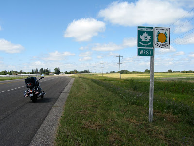
Time: six hours, 50 minutes (lots of stops)

Kilometres: 170.5

Weather:
Fort MacLeod: Overcast but bright, 20C at 10 AM
The Crow's Nest: Partly cloudy, 18 C at noon
Fernie: Partly cloudy, 26 C at 5 PM

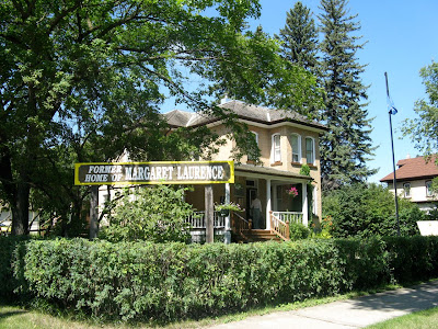
I have loads of pictures to show you, which I think will do much better than a written description. After checking into the Red Coat Motel (RCMP inspired) I went tof ra walk through historical Fort MacLeod. It took maybe 15 minutes for me to walk along main street and back. Most of the buildings are from 1903 to 1909. Not very historical, but I guess it is as the west really wasn't settled at that point.

One street over, and running parallel to Main Street is the actual fort. It was the training area for the RCMP (at that time I think they were still called the Northwest Mounted Police) in the west before the base operations moved east to Regina. The fort is a simple wooden pallisade. I didn't bother to go in as it was after 6 and it was most likely closed for the day.

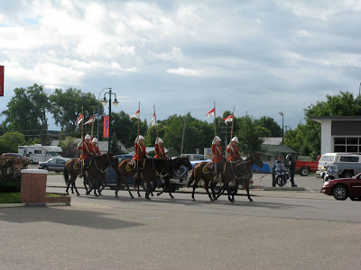
I got up early in the morning and began packing my bike. As I was playing with the bungee chords, I
heard the clip-clop of hooves. It took a second for the sound to register. When I looked up, the RCMP
was going by the hotel. Later on, as I pulled out of town, I purposely rode by the fort and found out that they do the Musical Ride twice a day, with the first performance at 10. I'd just
missed it.


I headed west, eagerly waiting for my first glimpse of the mountains. I could clearly see the foothills, but not the actual mountains. One of things on my "to see" list was the wind farm at Pincher Creek. I believe it is the largest in Canada, but I guess most of the are over the hills and not visible
from the Crowsnest Highway.
Nonetheless, I got a good shot of them along the top of a ridge. I think that the wind farm near Kincardine, Ontario is much bigger, but it is much windier in Pincher Creek.

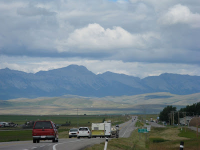
From just before reaching Pincher Creek, I could see both the foothills and the Rockies. I was so looking forward to this part of the trip.

Just up the highway from Pincher Creek is Lundbreck. I was now getting into the mountains. I'd been having big problems with my helmet speakers over the last few days, but I finally got them working for today's ride. Just as I rode through Lundbreck, Nightwish's Higher Than Hope was playing. It's a real juxtaposition to listen to symphonic goth while riding through the foothills and the mountains. So out of place.


My first stop was at the ruins of a coal mining operation. The stone washhouse foundations and first floor walls were still in tact. The tipple was long gone, but I could see where the footing were. Signs along the way told the story of how coal was mined in the area. I looked to the west and over one a hill I saw the peak of a huge stone mountain.

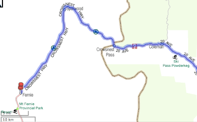
I turned a corner and came to the sign I'd bee waiting to see for such a long time: I was in the Crowsnest Pass

I soon rounded a corner and had a spectacular view of the area. It actually made my chin drop, but there wasn't a turnout on the road, so sorry, no pic.

My first stop was in Bellevue. I grabbed a quick sandwich and then headed for the mine, where I was given a miner hardhat and lamp. At the mouth of the coal mine was a thermometer. It was 2C. I was glad that I was wearing five layers of clothes. The first thing that hit me was the smell: sulphur. And, man, was it ever strong. the next thing that hit me was the very sudden temperature drop. I was only about three metres in the mine and it was close to freezing. The guide took a small group of us tourist down the main shaft of the mine. Because the shaft followed the vein of coal, the floor in level (but slopping downwards) but the ceiling and walls are not. The thick wooden beams holding up the ceiling are at angle and it really gave me the impression of being in a fun house at the midway. We were told to look at the floor if we
started to get disoriented. I was down the mind for about an hour. To me it was worth the $10,
but some people definitely would not like it.

In the parking lot was a couple of coal railroad cars. I reached into one of the cars and now have a nice, shiny (means it's very high grade) piece of coal as a souvenir of my visit to the Corwsnest.

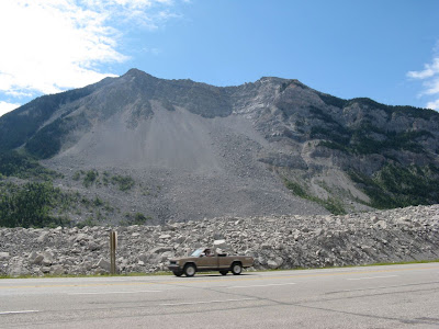
The most imposing feature of the Crownest is Turtle Mountain. That was the mountain I had seen from my the ruins of the wash house. The Indians called it Turtle Mountain because they believed it moved. Of course the white guys at the time thought that was a bunch of crap. They build the coal mining town of Frank at the base of Turtle Mountain. Then early one morning in April 1903, the mountain moved. Half the face came off and slid through the town of Frank and across the valley floor. Seventy people were killed. The miners working that night had to tunnel their way out.

Seeing the rock slide in photos doesn't begin to show the enormity of the event. Some of the rocks, I guess I should call them boulders, are the size of small house. Some of them were bigger than my 750 square foot apartment.

Here are two pictures. The first is of the Turtle Mountain. You can clearly see the area that gave way. The second picture was taken from the same spot, but I've turned around to show you how far the slide went and how big some of the smaller boulders were.
I'd heard about the slide years ago, and this was one of my main reasons for riding through the pass.

As I have known the story of the Frank Slide for years, there was no reason for me to go into the interpretive centre; but I went up there to get a broader view of the area.

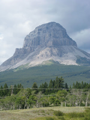
I can't end off today's post with showing you a picture of the mountain the pass was named after:


It was starting to get late in the afternoon, so I decided to call it a day. I had about an hours ride into Fernie, and I was looking forward to going for a swim


Saturday, August 14, 2010

Swift Current to Fort MacLeod


Day 8 – Friday August 13, 2010

Time: 7 hours, 45 minutes (including numerous stops)

Kilometres: 459.9

Weather:

Swift Current: Overcast and foggy, 12 C at 10 AM

Fort MacLeod: Overcast, periods of rain, 11 C at 5:30 PM

Last night was a Hotel California night. You know, “You can check out any time but you can never leave.” It was a bit creepy. I check in just after 5 PM and I was the only guest. The pool was closed, the restaurant was closed and the place looked like it was ready for a wrecking ball. Someone should put this Howard Johnsons hotel out of its misery. It was the second worst hotel I’ve ever stayed in. The only reason I didn’t get on my bike and go to anther hotel is because I was too tired, too wet, and too fed up with being on the bike. Enough was enough and I needed to relax.

The place wound up having about a dozen guests … many of them watching the Saskatchewan Roughrider take on some other team. These people are really into their football. They are probably as fanatic as Canadiens fans.

Anyway, I got up the morning and just wanted to hit the road and get the hell out of Dodge. I packed everything up and was ready to throw my bags on the bike. But then I looked outside and knew that today’s weather was going to scrap more of my tourist plans. It was rainy and foggy and I couldn’t see more than 5 kilometres in front of me.

At my first gas stop, I met the German guy from yesterday’s storm. He’d also stopped in Swift Current. He gave me his pen (most people have business cards) and invited me for a coffee when I go through Lilloot. He says he has the only radiator repair shop in town.

The fog didn’t lift. In fact, it sunk even closer to the ground as I rode westward. The plan was to loop south and ride through the Cypress Hills and then meet up with T’Can near the Alberta border. When I got to the turn off, visibility was only about 3 kilometres. There wasn’t any point in going south if I couldn’t see anything, so I continued westward. (On the following map, my route would have been to head south on hwy 37 then west on 13 (not on the map) and then north on hwy 21.)

By the time I hit the Alberta border the fog was lifting, but it was raining and the wind was picking up. I didn’t even stop at the “Welcome to Alberta” sign because I was in no mood to prolong the ride.

The further west I went, the worse the weather. Just before Medicine Hat, the sky opened up with a good soaking. I kept riding as I could see the road. It was a heavy concentration day, but even so, my mind wandered. I just haven’t been eating properly since I started the trip. It seems that everywhere I go the most convenient places to eat are Subway and Tim Hortons. I began to crave real food. Fruit, vegetables, good protein that isn’t stuffed between two pieces of bread. My list grew to salmon on a plank with a salad, cheese quiche with broccoli and corn on the side. I hadn’t had a banana or grapes in over a week. I pulled into Medicine Hat for lunch, found a Kelsey’s and they coincidentally have salmon served with a salad for lunch.

Some of the smaller storms, I contended with, but when I saw a big one, I knew to pull on the throttle and get into the next town. The next pull over was in Tabar. I pulled into a Tim Hortons, ordered a coffee and a muffin and watched while two storms flew over me.I quickly got back on the road, but as my hands were cold, I wore both my insulated waterproof gloves and the rain-off gloves. That helped a bit. I didn’t get very far before the skies started to look menacing again. At least it didn’t look as bad as what I’d gone through yesterday, but the wind was wicked. I was fighting with the bike all the time. At one point I thought I should pull over, but the next town was only a kilometre away and I could still see.

I pulled into Bow Spring, got gas and waited for another storm to pass. They were sweeping down from the north. I could see them coming and it was a bit of a game to judge whether I could make it to the next town before the next storm hit.

While in Taber, I saw what I fist thought was a family of Mennonites, simply because the way they were dressed. They were clearly farmers, but I didn’t think Mennonites were in Alberta and I know they don’t frequent Tim Hortons. When the family talk amongst themselves, I didn’t recognize the language. Perhaps they are Dukeabours (sp?)

The ride from Taber to Lethbridge wa pretty much the same: strong wind and quick, messy storms rolling through. I kept my eye open for downbursts, but thankfully, didn’t see any.

To give you an idea of how strong the wind was, I had to constantly lean the bike to the right to keep it upright. When I passed a stand of trees (not that often) or a train on the tracks that run parallel to the highway (more often than trees) or grain elevator ( every few kilometres) the wind would cease for a second, and then whip around and blow from my left., or sometimes, I’d just be sheltered and it was like normal riding. It was one of the best upper body workouts I’ve had in a long time.

Just outside of Lethbridge, I rode over a butte and saw the foothills of the Rockies. At first I wasn’t sure if I was looking at the foothills or storm clouds, but the closer I got, the clearer the outline became. I was almost at the end of my prairie journey.

I pulled into Fort MacLeod, check into the motel, unpacked my bags and had a quick shower. I needed to warm up (what else is new?) and feel clean after such a rotten day on the road.

The weather started to clear up a bit. It was still cold and windy, but at least it wasn’t raining. I walked down main street and found that one the street behind me is the actual fort. I hope to have time in the morning to quickly visit it.

I am so looking forward to tomorrow’s planned activities. The four things I’ve planned have been on my “to do” list for several years. See the Hillcrest mine site, go down the Bellevue coal mine, see the town (or what’s left of the town) of Frank, and then ride through the Crow's Nest Pass.

Friday, August 13, 2010

How many Kilometres?

Since I started this trip seven days ago, I've put 3,240.2 kilometres under my wheels. I've ridden more in the last week than I have have in any one month since I started riding.

Thursday, August 12, 2010

Yorkton to Swift Current

Day 7

Time: 8 hours, 45 minutes

Kilometres: 447.5

Weather:
Yorkton: Mostly cloudy, 22 C at 9:15 AM
Swift Current: Raining, 12 C at 5 PM

Last night I prepped my self and the bike for rain. I had all my rain gear in the hotel room and my riding clothes. Everything was packed on the bike overnight except my toothbrush and computer. I did all this because I know that when there is a chance of sever thunderstorms (as they were calling for) the storms usually go off with a bang in the heat of the afternoon.

I had the best night's sleep of the trip. I now know the difference between staying at a $70 a night hotel and a $100 a night hotel. They had a strict no noise policy in effect from 11 PM to 9 AM. Three or four 20-something boys were very loud in the area after 10 PM and they were told to leave (thankfully). As the night was off to a promising start, I didn't even put my earplugs in - and I didn't need them.

I had a quick breakfast in my room and pulled out of Yorkton at 9:15. the sky was overcast, but at least it wasn't raining. I put on all my rain gear except for my rain-0ff gloves, which I prefer not to ride in unless necessary. I rode through Yorkton and then headed south on Highway 10 towards Regina. In front of me was blue sky, but to my right, well off in the distance, were black clouds. I could see rain falling from the clouds and I planned to out race the storm to Regina.

In about half an hour I was riding under blue skies, but I could still the rain off to the north. Fortunately, the storm stayed away from me as I rode southwest.

I've always remembered the big, huge skies of Saskatchewan from when I drove through it 18 years ago. It was just as I recalled. You can see for ever. I still disagree when people say the Prairies are flat. They are rolling hills, much like Southern Ontario farmland. In Southern Ontario, we have the Niagara Escarpment as the main feature, while is Saskatchewan, they have rolling hills and beautiful valleys. Fort Qu'appelle and the Qu'Appelle Valley were breathtaking.

Bridge construction slowed traffic to a crawl as I descended into the valley. The Qu'Appelle river was very wide and the area was alive with water birds, including a group of four white pelicans which flew almost right over me. The ribs of the valley is what made the the area even more beautiful. Unfortunately, I couldn't get a good photo, so I've stolen this one from the Internet:

There was hardly a cloud in the sky, but the the day was heating up quickly. It was only 10:45 and the temperature was at 30C. I stopped in a Dairy Queen (my first of the trip) and then continued towards Regina.

Not long after leaving Fort Qu'Appelle, the sky in the west started to get cloudy. By the time I'd reached the junction of highways 10 and 1, I knew it would be foolish of me to stop in Regina. I wanted to see the RCMP museum and the changing of the guard at 12:30. I knew if I stopped that I would get stuck in some unpleasant weather. Perhaps I'll be able to see some of Regina on my return trip.

Here's a map of where I went during the first part of the day:

On the Saskatchewan licence plate is the catch-phase "Land of Living Sky." Watching the sky move is mesmerizing. I could see a solid storm front. The line in the sky is perfect. On the far side of the line was a small line of cumulus clouds.
Behind them were towering cumulus monsters. I watch the thermals push
the clouds higher, while the underside of the clouds grew darker. It was a fantastic sight to see.

I was keeping an eye on the storm but also keeping an eye open for towns. I didn't want to get stuck on the highway (the speed limit is 110, and I get nearly run over when I do 120 - I'm slow compared to others) in a downpour. My timing was perfect. As I pulled into the "Pilgrim Centre" in Caronport (just west of Moose Jaw). I'd been heading towards the storm for just over an hour. So I guess that means I saw it about 110 to 125 kilometres in the distance.

I hung out at the Centre for about an hour (it had a Husky gas station, Subway restaurant, and a convenience store). It was hardly raining when I left, but I decided to put on my rain-off gloves just incase ... and I was about to need them.

The sky cleared up quickly, but again, in the distance I could see storms. Just after Moose Jaw the landscape changed from gently rolling hills full of crops to ranch-type land. It was much more hilly, with lots of marshes. I saw a red-winged blackbird for the first time since leaving Ontario.

I was keeping my eyes on two storms: one to the left and the other to the right. I couldn't really see the one of the right, but I knew it was there. Over the tops of the large hills, I could see the mushrooms of distant cumulus clouds. These suckers were big!

The storm to my left was going to break first, but I was fortunate and it missed me by some distance (I really can't judge distance on the Prairies, but I would guess it missed me by about 5 kilometers). The storm to my right was really getting interesting and the more I was thinking "Oh, wow, this looks so cool!" I also knew "Oh, wow, this is really not good."

Since my stop at Caronport, another rider and myself passed each other a few times. He is a faster rider than me, but he also stops more often, so I would pass him while he stopped.

I knew that this storm was going to be a whopper when I was that the second line of thermals were dark blue. I love watching weather, so I knew I was in big trouble and needed to find shelter as soon as possible. In my rearview mirror I saw the other rider had caught up with me. In front, the storm was now sending down forks of lightning. The next town was only a couple of kilometres away. I pulled on the throttle.

Huge gusts of winds hit me from the side ... one even pushed me slightly into the passing lane. Within 10 seconds the wind picked up and down came huge globs of pelting rain. I didn't last long - maybe 30 seconds. There was a white camper van in front of me. If it wasn't for the camper, I wouldn't know which way to steer. I couldn't see a thing. It was time to pull over even though there was no shelter in sight.

I pulled off as far as I could onto the hard shoulder. Behind me, the other rider had also pulled over as well. I planned to leave everything on the bike and head down into the ditch at the side of the road. But when I looked back, I saw that the motorcycle behind me had gone over. I ran over to the rider, who was picking himself up from the shoulder. Together we picked up up his monster bike (it is the Yamaha version of a Honda Gold Wing - I would guess around 900 pounds without luggage). He pulled out a tarp from under his passenger seat and we hunkered down under it in the grass to wait out the storm.

We were there for about 30 seconds when a woman lifted up one end of the tarp. She was in a car and pulled over behind the other bike. She invited us into her car to ride out the storm. I wasn't about to wait for another invitation, and quickly jumped in the back seat of her car. We sat there, making small talk for about 15 minutes while the wind outside rocked the car back and forth.

She was from Regina and on her way to Lethbridge. The other rider, who I couldn't understand very well because of his thick German accent, was returning home to Lillooet, BC from a ride through Ontario.

It was really nice of woman to pull over and give us shelter. I know in the big city that sort of thing just doesn't happen. It's every person for themselves. What a shame we've lost that trust in others and the willingness to help others.

When the rain lightened up, I was the first one out of the car. I didn't want to overstay my welcome. I don't mind riding in normal rain, and that is what the storm had turned into. I asked the other rider if he needed an hand with anything (there was a broken off piece of something-or-other from his bike on the ground, and he still had to fold up the tarp). He said he was fine. I was quickly back on the road and searching for Swift Current.

I hadn't gone more than a kilometre when I saw the turn off to Waldeck. I'm glad that I didn't know how close I was to a turn off or I may have tried to push for it. So, my riding lesson for today is: Turn off to the shoulder when it gets too bad. I don't need a town to be safe.

About 10 minutes later I pulled off the highway and into Swift Current. It was still raining as I unpacked the bike. At least all the bugs from the Prairies have been blasted off the bike in nature's car wash. I didn't bother putting the cover on the bike as I'm hoping it was stop raining tonight and give my bike a chance to dry out. I don't want to trap all that moisture under a cover. Meanwhile, my hotel room is littered with drying clothes. It's supposed to rain again tomorrow afternoon, but hopefully not in such a dramatic fashion.

Sorry there aren't any pictures, but I was a bit too busy to take the rain cover off of my tank bag to get the camera. By the way, the rain cover doesn't work. The contents of that are hung out to dry. Here's a full map of the days ride:

Pictures from the Prairies

Here are the pictures I was going to post from yesterday's ride, but was too tired to last night.

First up, I stopped in Neepawa, Manitoba for gas and saw the sign indicating that house where author Margaret Laurence grew up was just around the corner. I couldn't pass up the opportunity to at least drive by it. And I was afraid of riding by it if it wasn't well signed.

I also FINALLY found a relatively safe place to pull over where there is a hard shoulder. Yup, I'm on the Yellowhead Highway heading west towards Yorkton. I didn't realize that there are two Trans Canada Highways out in the west. The first is the southern route and the northern route. The Yellowhead is the northern route and goes from Portage la Prairie up through Jasper. The southern route goes through Banff.

I crossed over into Saskatchewan but didn't realize until this morning that I'd crossed into Mountain Time. It would be nice if they put up a sign to let us tired travelers know these thing. Of course Saskatchewan is the only province that doesn't participate in daylight savings, so it is difficult to know whether or not to move the clock or not.

Wednesday, August 11, 2010

Winnipeg to Yorkton

Time: 7 hours, 10 minutes

Kilometres: 465.7

Weather:

Winnipeg: Sunny, 24 C at 10 AM

Yorkton, Sask: Partly cloudy, 28 C at 5 PM

I really don't understand why it took me so long to ride so few kilometres. I think I hit every red light on the way out of Winnipeg, but other than that, it was pretty smooth riding all the way through.

From Portage La Prairie up to Gladstone (small town about an hour or so north of PLP) there were thousands of those little white butterflies. You know the ones. They fly like they are drunk 'cause they just can't fly in a straight line. Anyway, what ever was growing at the side of the road was their favourite plants. Unfortunately, they all too often flew in front of me. At times it was almost like, but not quite as intense as light snow flurries.

I also discovered that dragonflies eat these butterflies. I think it is also mating season for dragonflies and there were a few flocks? schools? squadrons? ... I don't know the right term. But I could see them flying on the road ahead of me and there was nothing I could do to avoid them. Between the butterflies, dragonflies and the odd bee, there was barely a spot on my windshield free of bug splatter. I was also covered. Boots, helmet, arms and legs.

I pulled over for gas in Neepawa, Manitoba (is it pronounced Nee-pa-wa or Neep-awa?) and stumbled upon the childhood home of author Margaret Laurence. I didn't go inside as I was already running behind schedule, but I took a couple of photos.

A quick note about today's pics: It's just passed 11 PM and I haven't even looked at the pics I took today. I'm just too tired to do that now and will post those pics tomorrow night.

After Neepawa, the bug problem diminished quickly. I stopped in Russel, which is just east of the Sask border. Originally, I had planned to head north to visit the grain elevator museum, but as it was already close to 4 PM, I stopped for lunch at Subway and then headed west. I will have to ride another trip out this way in the future as I have so far missed three things on my "to see" list."

I rolled into Yorkton shortly after 5 PM. I soon found out about the weather warnings popping up all over the province. After a quick swim in the pool, I began repacking my gear and getting my Gore-Tex ready. Currently, the bike is packed except for a few items and will be ready to roll in about five minutes. The forecast is calling for rain starting tonight and going all the way through tomorrow. There is a good chance of thunderstorms. From weather watching, I know that sever thunderstorms usually pop up in the afternoon. I plan on starting early in the morning and will hopefully miss the worst of the weather. I will most likely miss another tourist destination in Regina and just keep heading west towards my hotel.

Tuesday, August 10, 2010

Winnipeg and Selkirk

Day 5 – Tuesday August 10, 2010 – Winnipeg and Selkirk

Time: Not much

Kilometres: 82.7

Weather:

Winnipeg: Sunny, humid, and warm; 28C at 10:20 AM

Selkirk: Hazy, hot, and humid; 42C at 2:10 PM

I got off to a late start as I had a luggage problem to solve – which I did thanks to the Velcro strap Diane gave me last week. Originally this was going to be used to hold my tank bag (which is scratching my paint) to the luggage on the back seat; however, I found the motorcycle cover fit on the back seat so I didn’t use the Velcro. I packed Velcro at the last minute for in case of emergency strapping. Yup, this was the emergency. All I did was stabilize the load from the top with strap.

I took the new luggage configuration for a test-run up to Selkirk, which is about 40 km north of Winnipeg. Actually, Lower Fort Garry was on my “must see” list. I hit the road at just before 11 AM after grabbing a quick bite to eat at Tim Hortons.

I went through downtown Winnipeg again and then headed north. Once out of the city there was a bit of road construction, but it didn’t really slow me down. I arrived at Lower Fort Garry at 11:50, which I thought was the perfect time as most people would be having lunch. (I have developed a habit of eating while others are doing things, and doing things while others are eating. There is hardly any waiting and not many people.)

As I had my big luggage with me, I took advantage of it my stowing my helmet and jacket it in. I was boiling hot and my motorbike stand bit into the newly-paved parking lot. I pulled out my handy little kickstand snowshoe so my bike tip over while I was off having fun.

Before leaving Toronto, I’d polled apart an old backpack and salvaged the shoulder straps. I created a quick release system and added it to the tank bag, which was perfect for today. I carried all my essentials and extra water. It worked flawlessly.

Lower Fort Garry is a rather small limestone fort, which was built in the 1870s. The governor of the fort oversaw all the Hudson Bay trading from here west to the Pacific. Upper Fort Garry is now under the concrete and glass structures of downtown Winnipeg. Apparently, only an old arch remains of the fort.

Lower Fort Garry is on the banks of the Red River. Before going into the fort I went down the river’s edge and found that it is not red, but brown. Between the out-buildings around the fort and the river was an old York river boat. Today it is used for demonstration purposes – how they built and maintained the boats that carried goods back and forth from the fort to York Factory on Hudson’s Bay. (Here’s a pic of the boat.)

There were two highlights of the fort for me. First was the blacksmith’s shop. (That’s the wooden building in the middle of the pictures, with the fort in the background.) The young smith noticed my motorcycle pants, and as was his only visitor, he started talking about bikes. After about five minutes a groups of people wandered into shop and the smith began pumping on the huge bellows. The embers of the forge erupted into flame and the smith picked up a long poker-like piece of blackened metal. He heated up the metal, turned to the anvil and began pounding. He must have been really hot. He was working up a sweat from the pounding plus he had the hot forge directly behind him. After pounding for a while, he dipped in water and then in it went into the fire and then back to anvil for more pounding. He tempered the metal several times until he finally pounded off the top and then flattened the top. His hard work and sweat paid off as he held up a 5 centimetre nail for all to see.

After the group left, he gave me the nail as a souvenir. He said that he messed up the end, but I was really happy with it. That is going to be a keeper for me.

Next, I went into the fort and talked with many of costumed interpreters. All were really friendly and full of interesting information. They were eager to answer questions, and because it wasn’t crowed, they took extra time with me to just chit-chat about history.

The second highlight was meeting the woman who played the part of the governor’s wife. She could see how into everything I was. We talked about heating (there are 15 stoves in the one house), what women did to relax (they will quickly lose their eyesight due to poor lighting and intricate sewing).

I was really intrigued with the dining room. The cutlery holder was like nothing I’d ever seen before (but neither of the picture turned out). I asked if I could cross into the roped off area and she soon gave me a short history of some of the pieces. The oldest is a wooden tea chest (I immediately thought of Margo), which goes back to the mid-1700s. She was such an interesting and fun person to talk with. Just as I was about to leave she paid me the nicest compliment. “It’s really nice to meet someone who really appreciates the history and is not here to just pass through.”

On the way out of the fort I saw a few Red River carts, which were known for there ear-splitting squealing. (Here’s a pic of three carts.)

In all, I was in the fort for just over two hours. When I returned to my bike, I was starting to dehydrate. I couldn’t believe how thirsty I was. Thankfully, I had water with me. I looked at the thermometer on the bike, which read a whopping 42 C. I’m sure some of the heat was reflecting back from the black pavement.

As I headed south with the highway wind cooling me down, I decided to get my earring taken care of. The good folk over at Urban Graffiti quickly fixed the problem and even gave me an extra ball “just in case.”

From the there I headed back to the hotel for a much needed dip in the pool and early dinner. While everyone is having dinner, I’ll go for another swim and then plan out my adventures for tomorrow.